Managing our Environment

Moa Creek Inland Saline Wetland

Description:

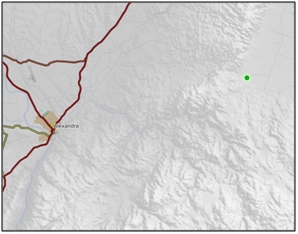
A small saline site on upper reaches of a broad alluvial plain to the east of Raggedy Range, adjacent to Crawford Hills Road. 1

Type/Class:

Inland saline. 2

Size:

3.3 ha.

Altitude:

440 - 480 m above sea level.

Approximate location:

1.8 km West of the intersection of Crawford Hills Road and Poolburn-Moa Creek Road, Moa Creek.
NZTM (centre point): E1334040 N4986970.

Regional Plan:

Water for Otago.
Schedule 9 Regionally Significant Wetland, no.106, Map F12.

Territorial Authority:

Cental Otago District Council.


Moa Creek Inland Saline Wetland

Recorded Values:

Value

Description

A1

Habitat for nationally or internationally rare or threatened species or communities. Threatened plant species kaupārerarera (Plantago spathulata) and remuremu (Selliera radicans) present. 1

A5

Scarce in Otago in terms of its ecological or physical character. Less than 18% of inland saline areas remain in Otago. 2

A2 - A4, A6 - A9

No relevant information is currently held by the ORC.


Other Information:

  • Soil classified as Saline Immature Semiarid Soil. 8

  • Other plant species found include Atriplex buchananii (threat status of naturally uncommon), Hordeum spp., Buck’s-horn plantain (Plantago coronopus), Puccinellia raroflorens (threat status of nationally critical), salt grass (Puccinellia fasciculata), salt grass (Puccinellia stricta) and Selliera microphylla. 8

  • Invertebrate species recorded include Arctesthes catapyrrha, Capua semiferana, Eurythecta zelaea, Kiwaia thyraula, Orocrambus corruptus and Paranotoreas fulva. 8 The small field cricket Nemobius sp. has also been recorded at this site. 44

  • The Department of Conservation considers the Moa Creek Inland Saline Wetland to be a moderately important site for biological conservation. On a scale from 1 (highest value) to 11 (lowest value) the site was given a rank of 5, on the basis of its geographical extent, relative representativeness (the extent to which the site represents the assumed 1840 condition), diversity and rarity of biota and soils. 8

  • Potential threats to the site include irrigation, cultivation, fertiliser application, oversowing, invasion by exotic weeds, grazing and trampling by stock. 8

  • Large sarsen stones found at this site have prevented ploughing. 44

  • Other moth species found are Kiwaia lenis, Scythris n.sp., Paranotoreas fulva and Loxostege n.sp. 45

  • Listed as an Area of Significant Indigenous Vegetation, Habitats of Indigenous Fauna and Wetlands in the Central Otago District Plan. 55


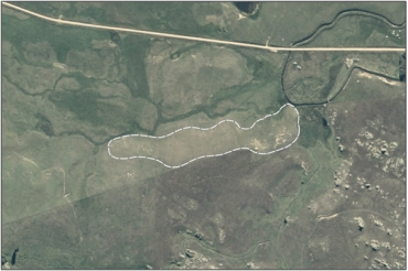
Aerial View of Moa Creek Inland Saline Wetland (March 2005)

Aerial View of Moa Creek Inland Saline Wetland (March 2005)

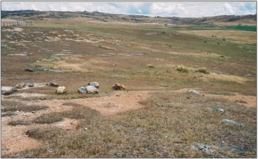
Moa Creek Inland Saline Wetland (March 2006)

Moa Creek Inland Saline Wetland (March 2006) 51

References:

1 Otago Regional Council (2004) Regional Plan: Water for Otago. Published by the Otago Regional Council, Dunedin.

2 Ausseil, A.G., Newsome, P., Johnson, P. (2008) Wetland Mapping in the Otago Region. Landcare Research Contract Report prepared for the Otago Regional Council.

8 Allen, R.B. and McIntosh, P.D. (1997) Guidelines for conservation of salt pans in Central Otago. Science for Conservation: 49. Published by the Department of Conservation, Wellington.

44 Fagan, B. and Pillai, D. (1992): Manorburn Ecological District: Survey report for the Protected Natural Areas Programme. New Zealand Protected Natural Areas Programme Series No. 22. Published by the Department of Conservation, Wellington.

45 Pers comm. B. Patrick, Entomologist, Otago Museum (2006).

51 Otago Regional Council – Photo Archive.

55 Central Otago District Council (2008) Central Otago District Plan, Published by Central Otago District Council, Alexandra.

Back to top
Online Maps & Data: