Managing our Environment

Hazeldale Fens

Description:

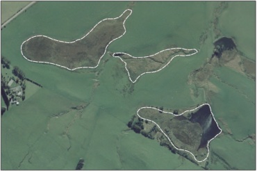
Palustrine wetland complex comprising a fen area that occurs in a shallow depression, a swamp adjacent to a large pond and a smaller area of boggy tussock lands. 35

Type/Class:

Fen, Bog and Swamp. 2, 35

Size:

9.6 ha.

Altitude:

280 - 320 m above sea level.

Approximate location:

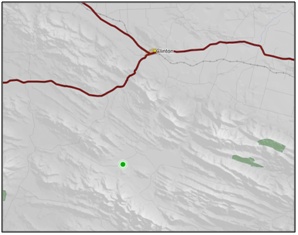
1.5 km Southwest of the intersection of Hazeldale Road and Owaka Valley Road, Clinton. NZTM (centre point): E1318420 N4867270.

Regional Plan:

Schedule 9 Regionally Significant Wetland, no.59, Map F49.

Territorial Authority:

Clutha District Council.


Hazeldale Fens

Recorded Values:

Value

Description

A4

High degree of wetland naturalness. 2

A1 - A3, A6 - A9

No relevant information is currently held by the ORC.


Other Information:

  • The fen, which comprises the northernmost wetland area, is made up mostly of copper tussock with ground cover of Sphagnum cristatum and wire rush (Empodisma minus). Patches of cutty grass/rautahi (Carex coriacea) or leafless rush/wīwī (Juncus gregiflorus) dominate, and pūkio (Carex secta) and mingimingi (Coprosma propinqua) is common. The inter-tussock cover is about 85% native with the remainder mostly pasture grass and the problem weed jointed rush (Juncus articulatus) also present. Other native species present include Pernettya macrostigma, little hard fern (Blechnum penna-marina) and Glen Murray tussock (Carex flagellifera). 35

  • There is moderate trampling damage to the wetland as there is stock access. 35

  • The hydrological integrity of the fen is good with only the lower end having been canalised to increase the width of the water course for freer drainage. 35

  • The fenced off swamp with a large pond, located in the south-eastern corner of the wetland complex, is dominated by copper tussock, leafless rush/wīwī (Juncus gregiflorus) and flax with many individuals of mingimingi (Coprosma propinqua) and cabbage tree. 35


Aerial View of Hazeldale Fens (March 2006)

Aerial View of Hazeldale Fens (March 2006)

References:

2 Ausseil, A.G., Newsome, P., Johnson, P. (2008) Wetland Mapping in the Otago Region. Landcare Research Contract Report prepared for the Otago Regional Council.

35 Kunzea Consultants (2008) Conservation Values Report – Freeholding Kuriwao Leasehold Estate – “Limberlost”. Report prepared for the Otago Regional Council, Dunedin.

Back to top
Online Maps & Data: