Matukituki Valley Wetland Management Area
Description:
The area comprises three remnants of a large wetland system that once covered much of the Matukituki Valley: the West Wanaka Lagoons, the Narrow Spur Wetland and the Broad Spur-Tongue Spur Wetland. Swamps, bogs and open water together represent the largest complex of lowland wetlands in the Lakes Ecological Region. The three wetlands support similar floristic and faunistic values and retain much of their original character. 1
Type/Class:
Swamp and bog. 1
Size:
75.6 ha.
Altitude:
280 - 300 m above sea level.
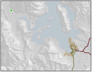
Approximate location:
10 km Northwest of the intersection of West Wanaka Road and Wanaka-Mount Aspiring Road, Glendhu Bay.
NZTM (centre point): E1275600 N5056400.
Regional Plan:
Water for Otago.
Schedule 9 Regionally Significant Wetland, no.98, Map F5.
Territorial Authority:
Queenstown Lakes District Council.
Recorded Values:
Value
|
Description
|
A1
|
Habitat for nationally or internationally rare or threatened species or communities. Habitat for the Olearia lineata (At Risk – Declining). 90 |
A2
|
Critical habitat for the life cycles of indigenous fauna which are dependent on wetlands. Critical feeding and nesting area for a wide variety of waterfowl and waders including the New Zealand shoveller/Kuruwhengi (Anas rhynchotis variegata), Crested Grebes (Podiceps sp.), Pied Stilt (Himantopus himantopus), Black Shag (Phalacrocorax carbo novaehollandiae) and Black Swan (Cygnus atratus). 1, 42 |
A3
|
High diversity of wetland habitat types. 1 |
A4
|
High degree of wetalnd naturalness. 1 |
A6
|
Highly valued by Kai Tahu for cultural and spiritual beliefs, values and uses, including mahika kai and waahi taoka. Wetlands highly valued by Kai Tahu for presence of longfin eel (Anguilla dieffenbachii). 1, 42 |
A7
|
High diversity of indigenous wetland flora and fauna. High diversity of native birds, insects, aquatic and plant life. 1 |
A5, A8, A9
|
No relevant information is currently held by the ORC. |
Other Information:
Aerial View of Matukituki Valley Wetland Management Area (February 2007)
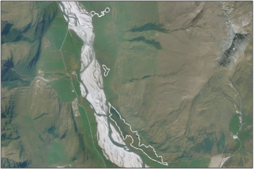
Matukituki Valley Wetland Management Area (April 2010) 94
Matukituki Valley Wetland Management Area (October 2007) 94
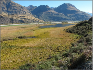
- The Broad Spur–Tongue Spur Wetland is a small wetland pond/swamp system. The majority of the wetland is fenced to exclude stock. An exception is an area under the toe slopes of the Buchanan Peaks. Some water is diverted away from the wetland by a ditch at the base of the hill parallel to the farm track. 42
- The Narrow Spur Wetland is a substantial area of approximately 60 ha lying on the Matukituki Flats to the south of Narrow Spur. Drainage ditches have been constructed to lower the water table and to turn inflows more directly to the Matukituki River. Inflow from toe slopes is now collected by drainage ditches. 42
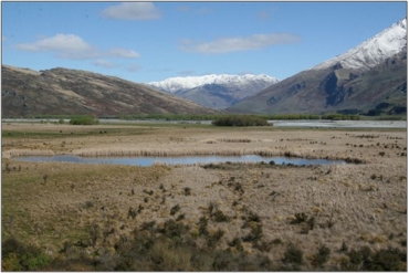
- The West Wanaka Lagoons is the single largest remaining lowland wetland in the Lakes Ecological Region and is approximately 230 ha. 42
- These 3 wetlands support similar botanical values and still retain much of their natural character. Parts of the wetlands without permanent standing water contain many native woody species including mingimingi (Coprosma propinqua), scented tree daisy (Olearia odorata, threat status of declining), Olearia lineata, and koromiko (Hebe spp.). These shrubs are often draped in bush lawyer (Rubus schmidelioides). The dominant natives at ground level include pūkio (Carex secta), cutty grass/rautahi (Carex coriacea), jointed rush (Juncus articulatus), swamp kiokio (Blechnum minus), little hard fern (Blechnum penna-marina) and sharp spike sedge (Eleocharis acuta). Exotic pasture plants are also common, including clovers, Yorkshire fog (Holcus lanatus), browntop (Agrostis capillaries) and sweet vernal (Anthoxanthum odoratum). On the margins of permanent pond areas raupo (Typha orientalis) stands are present. It is thought that this species has probably spread as water levels have been progressively lowered through construction of drains. Crack willow (Salix fragilis) is also present on margins of areas with standing water. Maori sedge (Carex maorica), Carex gaudichaudiana and toetoe (Cortaderia richardii) form a discontinuous sward where the natural water edge appears to have been relatively stable. Hydrocotyle sulcata, water forget-me-not (Myosotis laxa) and water buttercup/waoriki (Ranunculus amphitrichus) form an understory and ground cover. In open water areas common water milfoil (Myriophyllum propinquum) and red pondweed (Potamogeton cheesemanii) occur. 42
- Species of bird present include Wrybill/Ngutuparore (Anarhynchus frontalis), South Island Pied Oystercatcher (Haematopus ostralegus finschi), Banded Dotterel (Charadrius bicinctus bicinctus), Mallard (Anas platyrhynchos), Canada Goose (Branta canadensis), South Island Fernbird (Bowdleria punctata punctata), Marsh Crake (Porzana pusilla affinis) and Spotless Crake (Porzana tabuensis plumbea). New Zealand Scaup (Aythya novaeseelandiae) have been observed in the vicinity of the West Wanaka Lagoons but probably reside in Lake Wanaka. 42
- Invertebrate species present include damsel-flies and three species of crane flies (Tipulidae). 42
- The West Wanaka lagoons were ranked as a wildlife habitat of moderate to high value in 1982 when the area was surveyed by the Wildlife Service. 42
- Populations of juvenile and adult brown trout (Salmo trutta) are found within the West Wanaka Lagoons and adjacent wetlands. 43
References:
1 Otago Regional Council (2004) Regional Plan: Water for Otago. Published by the Otago Regional Council, Dunedin.
42 Land Information New Zealand (2002) Crown Pastoral Land Tenure Review: West Wanaka Station. Conservation Resources Report for the Commissioner of Crown Lands. Published by Land Information New Zealand, Wellington.
43 Land Information New Zealand (2005) Crown Pastoral Land Tenure Review: West Wanaka Station. Fish and Game Report. Published by Land Information New Zealand, Wellington.
90 Department of Conservation (2010) Comments on the Consultative Draft Proposed Plan Change 2 (Regionally Significant Wetlands) to the Regional Plan: Water for Otago. Department of Conservation - Otago Conservancy, Dunedin.
94 Department of Conservation – Photo Archive.