Shotover River Confluence Swamp
Description:
Wetland area located upstream of a roche moutonnée (rock formation created by the passing of a glacier) at the historic confluence of the Shotover and Kawarau Rivers. 92
Type/Class:
Swamps. 102
Size:
15.2 ha.
Altitude:
300 - 320 m above sea level.
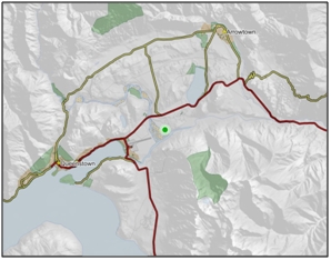
Approximate location:
East of the confluence of the Shotover River and Kawarau River, Frankton.
NZTM (centre point): E1267000 N5007200.
Regional Plan:
Water for Otago.
Schedule 9 Significant Wetland, no.137, Map F8.
Territorial Authority:
Queenstown Lakes District Council.
Recorded Values:
Value
|
Description
|
A1
|
Habitat for nationally or internationally rare or threatened species or communities. Habitat for the Olearia lineata (At Risk – Declining). 27, 92, 102 |
A3
|
High diversity of wetland habitat types. The variety of plant communities within such a small area is remarkable. Twenty-one species of native plants have been recorded in the wetland. Bird species observed on the wetland include Pukeko, shelduck and harrier, while the wetland also provides possible habitat for crake, scaup, shoveller, black fronted tern and plover. 92 |
A5
|
Scarce in Otago in terms of its ecological or physical character. Located in the Shotover Ecological District where only c.0.01% of land cover comprises herbaceous freshwater vegetation and c.7.25% lakes and ponds. 102 |
A2, A4, A6 - A9
|
No relevant information is currently held by the ORC. |
Other Information:
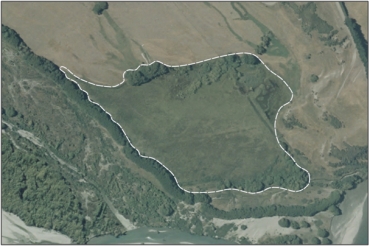
Aerial View of Shotover River Confluence Swamp (February 2006)
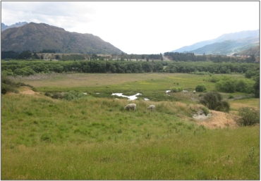
Shotover River Confluence Swamp (December 2010) 51
- Part of the Kawarau Catchment Wetland Complex, described as wetland complex that meets the Ramsar Convention standards of international quality. 14
- The wetland has been subject to modification with the installation of drains and the creation of ponds in the north-east area of the wetland. 92
- The vegetation in the wetland is distributed according to patterns of soil drainage and/ or moisture (directly related to gentle topographical undulations). 92
- Carex virgata is dominant near the centre of the wetland. 102
- The vegetation communities recorded in the ponds and open drains with standing water include the sharp spike sedge (Eleocharis acuta), jointed rush (Juncus articulatus), duckweed (Lemna minor), pondweed (Potamogeton cheesemanii), water buttercup (Ranunculus trichophyllus), watercress (Rorippa nasturtium aquaticum), and starwort (Callitriche stagnalis), rautahi and a few purei (Carex secta). 92, 102
- Vegetation communities within the permanently saturated area of the wetland, located toward the north, east and north-east margins of the wetland, are dominated by Raupo (Typha orientalis), Juncus articulates, reedland-purei (Carex secta) sedgeland the later being prominent in shallower water. 92
- The largest area of the wetland is seasonally saturated and its vegetation consists of the mosaic of sedgeland, rushland and willows and is described below:
- Rautahi Sedgeland – Giant buttercup (Ranunculus acris), Festuca rubra and the bright green swards of the native Carex gaudichaudiana are common throughout the sedgeland. This community also includes numerous introduced pasture grass species including creeping bent (Agrostis stolonifera), white clover (Trifolium repens), lotus (Lotus pedunculatus) where conditions are comparatively drier. Jointed rush (Juncus articulatus) rush is abundant to the north of the wetland. 92, 102
- Soft Rush Rushland – Carex sedgeland - The soft rush (Juncus effusus) is a dominant species within this community however rautahi, Purei (Carex secta) and Carex geminata are also important components. Jointed rush and introduced pasture grass species are abundant throughout.
- The rushland-sedgeland is infested with saplings and shoots of crack willow (Salix fragilis) which are only being suppressed by browsing cattle. On the northern margins of the site tall crack willow form a canopy over Yorkshire fog, sweet vernal, Mimulus mochatus and open water with duckweed (Lemnor minor). Other problem plants of note in this area include grey willow (Salix cinerea), buddleia (Buddleja davidii), and tree lupin (Lupinus arboreus). 92, 102
- Other species present include cocksfoot, sweet vernal, browntop and Galium palustre. 102
- Olearia lineate (At Rick-Declining in de Lange et al. 2009) and Olearia virgata (Not threatened) were also recorded at the wetland. 102
- Soil classified as Deep Silt Loam of moderate fertility. 92
- Australasian Harrier (Circus approximans) and Pukeko (Porphyrio melanotus) were recorded on the wetland. 102
- Based on the diversity of habitat types in and around the area, diverse and abundant avifauna is anticipated. Other native and naturalised species that may inhabit and or visit the site include Spur-wing Plover (Vanellus miles), New Zealand Pipit (Anthus novaeseelandieae), Silvereyes (Zosterops lateralis), Black Fronted Terns (Sterna albostriata), New Zealand Eastern Falcon (Falco novaeseelandiae), White Faced Herons (Ardea novaehollandiae), Australasian Bittern (Botaurus poiciloptilus), Crake (Porzana sp.) and the waterfowl New Zealand Scaup (Aythya novaeseelandiae), New Zealand Shoveller (Anas rhynchotis) and Grey Duck (Anas superciliosa). All of these species, with the exception of Crake and Bittern, are known to inhabit (at least seasonally) the adjacent lower Shotover River and ponds of the surrounding Wakatipu Basin. Crake and Bittern have been recently recorded at Lake Hayes, only 3 km to the north-east of the wetland site. 92
- Introduced bird species seen recorded in or near the wetland include Skylark (Alauda arvensis), Californian Quail (Callipepla california), Goldfinch (Carduelis carduelis), Redpoll (Carduelis flammea), Greenfinch (Carduelis chloris) Chaffinch (Fringilla coelebs) and Blackbird (Turdus merula). 92, 102
- Other species likely to inhabit the area include Mallard (Anas platyrhynchos), Yellowhammer (Emberiza citrinella), Redpoll (Carduelis flammea) and House Sparrow (Passer domesticus). 92
References:
14 Cromarty, P. and Scott, D.A. (eds.) (1995) A Directory of Wetlands in New Zealand. Published by the Department of Conservation, Wellington.
27 De Lange, P.J. and Norton, D.A. (eds.) (1997) New Zealand’s loranthaceous mistletoe. Proceedings of a workshop hosted by Threatened Species Unit, Department of Conservation.
51 Otago Regional Council – Photo Archive.
92 Natural Solutions for Nature Ltd. (2010) Ecological Assessment and Recommendations for Enhancement. Shotover Country, Stalker Road, Queenstown. Report prepared for Ladies Mile Partnership, Queenstown.
102 Wildland Consultants (2011) Ecological evaluation of seven wetlands in relation to proposed Plan Change 2, Regional Plan water for Otago. Report prepared for Otago Regional Council.