Nenthorn Ridge Wetland Management Area
Description:
A wide variety of wetland types including a low turf ephemeral tarn, a medium turf ephemeral tarn, Purei wetlands, pools, bogs and moist red tussock (Chionochloa rubra) grasslands in a relatively small area on the upper slope and ridge crests of the Rolling Hills land system. 1
Type/Class:
Swamps. 2
Size:
67.0 ha.
Altitude:
480 - 600 m above sea level.
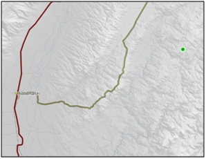
Approximate location:
4.8 km East of the intersection of Nenthorn Road and Ramrock Road, Nenthorn.
NZTM (centre point): E1396010 N4962740.
Regional Plan:
Water for Otago.
Schedule 9 Regionally Significant Wetland, no.112, Map F59.
Territorial Authority:
Waitaki District Council.
Recorded Values:
Value
|
Description
|
A1
|
Habitat for nationally or internationally rare or threatened species or communities. The threatened herb Gratiola nana is present in the low turf ephemeral tarn at Emerald Creek, one of only 23 known locations throughout the South Island (Johnson 1993a 47). Two locally rare species Elatine gratioloides and Glossostigma sp. occur in the medium turf ephemeral tarns. 1, 2 |
A3
|
High diversity of wetland habitat types. A high diversity of wetland habitat types present. 1 |
A5
|
Scarce in Otago in terms of its ecological or physical character. Less than 15% of swamps remain in Otago. 2 |
A6
|
Highly valued by Kai Tahu for cultural and spiritual beliefs, values and uses, including waahi taoka and mahika kai. 1 |
A7
|
High diversity of indigenous wetland flora and fauna. A very diverse range of wetland vegetation, a distinctive insect fauna and a diverse and relatively abundant waterfowl fauna (refer Bibby 1997, page 86-88 for details of species present, 98 and Johnson 1993c 99). 1 |
A2, A4, A8
|
No relevant information is currently held by the ORC. |
Other Information:
- Listed as an Area of Significant Indigenous Vegetation and Habitat of Indigenous Fauna in the Waitaki District Plan. 12
- Seven main habitat/vegetation types have been recorded in the Nenthorn Ridge Wetland Management Area in a report for the Department of Conservation prepared by P. Johnson of Landcare Research. 47
- Red tussock grassland (Chionochloa rubra) occupies gently sloping stream head basins on moist mineral soil. The main associated plants are browntop (Agrostis capillaries), tall Juncus sp. species, occasional sedge tussock (Schoenus pauciflorus), and Oreobolus strictus. Much of the ground cover is of the mosses Hypnum cupressiforme and Polystrichum sp. and the lichens Stereocaulon ramulosum and Cladia aggregata.
- Turf depressions that are seasonally inundated hollows without surface outlets. Turf plants form an almost complete and uniform cover in each depression. Plant composition is variable, but the common dominants are Carex gaudichaudiana and creeping bent (Agrostis stolonifera). Other species which contribute 10% or more of the cover are Hypsela rivalis, Gratiola concinna (classified as nationally vulnerable), Isolepis aucklandica, toad rush (Juncus bufonius), Lachnagrostis sp., Polytrichum sp. and Drepanocladus sp. In an upper zone of turf the dominant plants become dichondra (Dichondra brevifolia), piripiri (Gonocarpus micranthus) and dwarf bedstraw (Galium perpusillum).
- Pools contain common aquatics: common water milfoil (Myriophyllum propinquum), blue sweet grass (Glyceria declinata), kneed foxtail (Alopecurus geniculatus), jointed rush (Juncus articulatus) and Ranunculus glabrifolius.
- Juncus sp.-Carex sp. swamp, where pūkio (Carex secta) is found on shallow peat. Patches are dominated by one or more of the tall rushes leafless rush/wīwī (Juncus gregiflorus) and leafless rush (Juncus conglomeratus), makura (Carex diandra) and red tussock (Chionochloa rubra).
- Sphagnum sp. bog with patches 10-15m across. Orange-brown cushions of Sphagnum cristatum grows with Carex gaudichaudiana. Sphagnum falcatulum grows within watery hollows.
- Narrow-leaved snow tussock grassland. Narrow-leaved snow tussock (Chionochloa rigida) and fescue tussock (Festuca novae-zelandiae) are the main cover on soils drier than those under red tussock (Chionochloa rubra). Browntop (Agrostis capillaries) and mouse-ear hawkweed (Hieracium pilosella) are also common.
- Dry land turf. On sunny slopes mouse-ear hawkweed (Hieracium pilosella) is the predominant plant cover, with Carex riparia scattered. Other native plants that are abundant are Leptinella serrulata with a threat status of naturally uncommon, dwarf mingimingi/Pātōtara (Leucopogon fraseri) and turf mat daisy (Raoulia subsericea).
- Tors. These provide are range of different habitats such as sunny ledges, shaded clefts, and small caves. A diverse range of shrubs are found including Carmichaelia virgata, Carmichaelia crassicaulis with a threat status of declining, leafy coprosma (Coprosma parviflora), mountain korokio/korokio (Corokia cotoneaster), prickly mingimingi/hukihuki (Cyathodes juniperina), turpentine scrub (Dracophyllum uniflorum) with a threat status of naturally uncommon, bush snowberry/koropuka (Gaultheria antipoda), poataniwha (Melicope simplex), porcupine shrub (Melicytus alpinus), small-leaved pohuehue/pōhuehue (Muehlenbeckia complexa) and weeping matipo (Myrsine divaricata).
- This area is of interest to the Department of Conservation as it is habitat to 7 lizard species. 47
- Gratiola concinna has a threat status of nationally vulnerable and is in gradual decline. 48
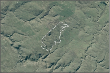
Aerial View of Nenthorn Ridge Wetland Management Area (March 2005)
References:
1 Otago Regional Council (2004) Regional Plan: Water for Otago. Published by the Otago Regional Council, Dunedin.
2 Ausseil, A.G., Newsome, P., Johnson, P. (2008) Wetland Mapping in the Otago Region. Landcare Research Contract Report prepared for the Otago Regional Council.
12 Waitaki District Council (2004) Waitaki District Plan. Published by the Waitaki District Council, Oamaru.
47 Johnson, P.N. (1993a) Emerald Creek, Nenthorn: Botanical report on wetlands. Conservation Advisory Science Notes No. 49. Published by the Department of Conservation, Wellington.
48 Flora Search Engine - New Zealand Plant Conservation Network Online. http://www.nzpcn.org.nz.