Manuherekia Rohe (Area)
Please note, ORC uses the Kāi Tahu spelling of Manuherekia.
We are developing a Land and Water Regional Plan (LWRP) in partnership with Kāi Tahu whānui, and with feedback from the greater Otago community.
Join the kōrero on the proposed direction of the Plan to care for Otago's lakes, rivers and streams and guide the activities that impact them.
We have a summary of proposed new rules and regulations that we encourage you to look over.
Get involved
Read all about the draft Plan and the proposed new rules and regulations:
Previous community consultation
We’re developing a new Land and Water Plan, including specific rules and limits on water and land use in your rohe (it means "area" in te reo).
The Manuherekia Rohe community is one of the first areas in the region ORC has worked with to develop a preferred approach to water and land management. This area was prioritised (along with the Arrow and Cardrona catchments) due to the presence of a large number of expiring deemed permits in the rohe, as well as the policy work already completed in these areas.
Between September 2019 and June 2021, community consultation was undertaken to identify important values and develop objectives and limits for waterways in the Manuherekia Rohe.
As part of this consultation community feedback was sought from the community on five Manuherekia Water Management scenarios. Two public meetings were held in Alexandra and Ōmakau. We received over 1,000 submissions supporting a range of flow options for the river.
The scenarios were developed with input from the Manuherekia Reference Group (MRG). The MRG included representatives from the Manuherekia Catchment Group (MCG), the Department of Conservation, Forest and Bird, Central Otago District Council, Fish and Game, the Central Otago Environmental Society, Southern District Health Board and ORC.
Following consultation, a report outlining a proposed approach was presented to ORC Councillors in August 2021. ORC Councillors requested that more science work be done, and this is now underway.
Thank you to everyone who provided feedback or came along to one of the community meetings in the Manuherekia Rohe to tell us what you want for land and water resources in this rohe.
You can view a summary report of the submissions, as well as the full set of submissions below.
Media release - Summary report on Manuherekia Management Scenarios consultation
May 2021 Manuherekia Management Scenarios consultation document.
Manuherekia Scenarios Consultation report
August 2021 council report
Submissions received
The preferred approach will be drafted into the Manuherekia Rohe chapter of the proposed Land and Water Regional Plan.
The new plan will be notified 30 June 2024. Once this plan is notified, you can make a submission saying what you like or how it could be improved.
About the area
Under national legislation, regional councils must manage waterways at an appropriate scale for setting freshwater objectives and limits.
ORC has therefore set five Freshwater Management Units (FMUs). As the Clutha Mata-Au FMU is large, it has been further divided into five rohe (areas), one of which is the Manuherekia Rohe – based on the catchment area of the Manuherekia River.
Work between the community and ORC to develop specific objectives, policies and rules to manage water in the rohe started in 2019. A key part of the work for this rohe involves the Manuherekia Reference Group (MRG), which is made up of a range of key stakeholders who ORC meets with monthly.
The MRG represent the wide-ranging interests of the community and have assisted ORC to develop options for water flow management which are now being discussed with the wider community (details below).
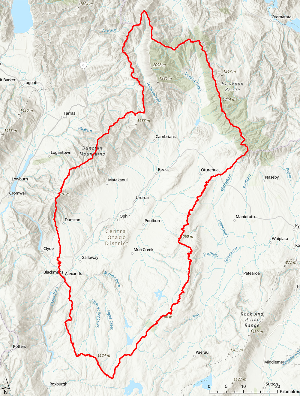
Map of the Manuherekia Rohe
Download map (PDF)
Economic profile
While freshwater policies might be designed and applied specifically to the Roxburgh Rohe, their impacts may be felt beyond. Hence the Roxburgh Rohe, the neighbouring Manuherekia Rohe, and the northern part of the Taieri Rohe are combined when considering socio-economic information. These communities have close economic ties, i.e., residents are likely to live in one of the areas while working/spending in the other areas. The three areas combined are referred to as the ‘Inland’.
In 2018, the area was home to around 13,000 residents (6% of Otago’s population), which had increased by 15% since 2006. The economy of this area depends on the water-reliant agriculture sector (which provides for one in five jobs) and tourism related industries (15% of all jobs). Administrative Services (13%) is the third largest sector in the area; and the Employment Services sub-category provides 10% of all jobs. Together, all these industries account for around half of the employment in the ‘Inland’ area.
An understanding of Māori history and the Māori economy is essential for policy development and policy impact assessment. Not only does pre-European Māori history help shape modern day New Zealand, but the Māori economy is also integral to the New Zealand economic system. ORC is partnering with Aukaha and Te Ao Marama to develop an overview of Kāi Tahu history and economy. This work will be included in the economic impact assessment, available 2023.
Manuherekia, Roxburgh and Upper Taieri Economic Snapshot
2021 Economic Studies to support minimum flows
Science profile
The Manuherekia Rohe is located between the Dunstan Range to the west, the St Bathans Range to the north, the Hawkdun Range and Rough Ridge to the east and the Knobby Range to the South. The Manuherekia River, the rohe’s main water body, flows over a distance of 85 km in a south-west direction towards Alexandra where it joins the Clutha Mata-Au River. The rohe stretches over a total area of approximately 3,000 km2. The climate of the Manuherekia Rohe is semi-arid, characterised by cold winters, warm, dry summers and low rainfall. The area is dominated by pasture grasslands on the flat and gently sloping land, while tussock grasslands are common in the high country. Urban development exists at the lower end of the rohe in Alexandra, and small but growing settlements at Omakau and Ophir.
Analysis of Manuherikia River Flow Data 2023
Application by Matakanui Station Limited to Take water from Neds Creek
CHES Implementation for the Manuherekia River, Otago
Discharge Gauging Data for the Manuherekia Catchment
ESPC Briefing Paper - Manuherekia Minimum Flow Update
Instream Habitat and Minimum Flow Requirements in the Manuherekia River 2016
Interim Review of the Manuherekia Hydrological Flow Models 2020
Invertebrate Drift Flow Relationships Comparison Between the Manuherekia and Other Rivers 2023
Invertebrate Drift Relationships for the Lower Manuherekia River Memo 2021
Lauder Creek Hydrology Report 2021
Management Flows For Aquatic Ecosystems In The Manuherekia River And Dunstan Creek 2016
Manuherekia Catchment Goldsim Model Scoping Document (Revised Draft) 2020
Manuherekia Catchment Hydrology Joint Expert Statement Revised Draft 2023
Manuherekia Catchment Hydrology Model Report 2022
Manuherekia Hydrology Report 1 2020
Manuherekia Catchment Hydrology Joint Expert Statement Revised Draft 2023
Manuherikia climate change assessment
Manuherikia Fish risk assessment
Manuherekia minimum flow scenario assessments
Manuherikia Hydrology model - calibration
Manuherikia hydrology model - ecology
Manuherikia Hydrology Model - scenarios
Manuherikia Hydrology Model Report
Manuherikia invertebrate drift study
Manuherikia natural character assessment
Manuherikia recreation study
Manuherikia water quality state and trends
Manuherikia Catchment Hydrology Model Comparison: Initial Review Of The Manuherikia Catchment Goldsim Model 2019
Natural Flow Relativities and Travel Times Between Water Level Recorder Sites on the Manuherikia River
Invertebrate Drift Flow Relationships Comparison Between The Manuherekia And Other Rivers 2023
Thomsons Creek Hydrology Report 2021
Water takes from Lauder Creek and Clear Creek within Lauder Creek and Muddy Creek Subcatchments, Manuherekia Catchment
Flow Requirements For Fish Habitat In The Chatto, Lindis, Manuherekia, Pomahaka And Waianakarua Rivers
Climate change assessment
Drift study
Natural character assessment
Recreation study
Manuherekia Water Quality State and Trends Technical Report
Hydrology Model - calibration
Hydrology Model - ecology
Hydrology Model – scenarios
Habitat modelling
Note that the memoranda on the Hydrology Model (Calibration, Ecology and Scenarios) are currently in draft form. The hydrology model and habitat modelling is currently being reviewed.
Want to know more?
Contact your rohe's Catchment Advisor for advice and assistance on sustainable land management practices that protect Otago’s waterways.
Sign up to our monthly newsletter On Stream for regular updates
Email customerservices@orc.govt.nz
Tel 0800 474 082