ORC Land and Water Regional Plan - Roxburgh FMU


Roxburgh Rohe (Area)

We are developing a Land and Water Regional Plan (LWRP) in partnership with Kāi Tahu whānui, and with feedback from the greater Otago community.

Join the kōrero on the proposed direction of the Plan to care for Otago's lakes, rivers and streams and guide the activities that impact them.

We have a summary of proposed new rules and regulations that we encourage you to look over.

Get involved

Read all about the draft Plan and the proposed new rules and regulations:


About the area

Under national legislation, regional councils must manage waterways at an appropriate scale for setting freshwater objectives and limits.

ORC has therefore set five Freshwater Management Units (FMUs). As the Clutha/Mata-Au River is the largest in New Zealand, by catchment and volume, the FMU has been further divided into five rohe (areas).

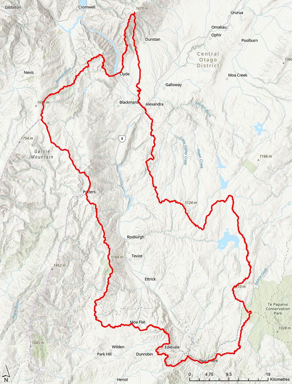
The Roxburgh Rohe extends from the Clyde Dam to Beaumont, and covers Alexandra, Clyde, and Roxburgh. The rohe includes some important tributaries for the Clutha/Mata-Au, such as the Fraser River (also known as The Earnscleugh), Benger Burn, Teviot River, and Beaumont River. Lake Roxburgh is roughly in the middle of the rohe along the Clutha Mata-Au River, while the Fraser and Teviot river catchments host the Fraser Dam and Lake Onslow, respectively.

The Clutha Mata-au River is important in Kāi Tahu traditions and history and mana whenua has an ongoing relationship with wāhi tupuna and mahika kai values. The area is also home to wetlands, galaxiids, and landscapes with high natural character.


Map showing the boundaries of the Roxburgh Rohe

Map showing the boundaries of the Roxburgh Rohe

Download map (PDF)


Economic profile

While freshwater policies might be designed and applied specifically to the Roxburgh Rohe, their impacts may be felt beyond. Hence the Roxburgh Rohe, the neighbouring Manuherekia Rohe, and the northern part of the Taieri Rohe are combined when considering socio-economic information. These communities have close economic ties, i.e., residents are likely to live in one of the areas while working/spending in the other areas. The three areas combined are referred to as the ‘Inland’.

In 2018, the area was home to around 13,000 residents (6% of Otago’s population), which had increased by 15% since 2006. The economy of this area depends on the water-reliant agriculture sector (which provides for one in five jobs) and tourism related industries (15% of all jobs). Administrative Services (13%) is the third largest sector in the area; and the Employment Services sub-category provides 10% of all jobs. Together, all these industries account for around half of the employment in the ‘Inland’ area.

An understanding of Māori history and the Māori economy is essential for policy development and policy impact assessment. Not only does pre-European Māori history help shape modern day New Zealand, but the Māori economy is also integral to the New Zealand economic system. ORC is partnering with Aukaha and Te Ao Marama to develop an overview of Kāi Tahu history and economy. This work will be included in the economic impact assessment, available 2023. 

Roxburgh Rohe, Manuherekia Rohe and Upper Taieri Economic Snapshot


Science profile

The Roxburgh Rohe covers around 180,000 hectares of land, with grassland being the most common land cover. Low-producing grasslands that brown off over summer, such as that found on steep hill and high country, occupy 32% of the rohe while high-producing grasslands such as intensified grazing occupy 29%. These grasslands are mainly used for farming. Tall tussock grasslands cover 24%, and exotic forests cover 2% of the rohe. The exotic forests are mostly Pinus radiata, Douglas fir and Eucalyptus.

The primary land use is dry stock farming. This consists mainly of pasture grazing beef cattle, sheep, and deer for meat, wool, and velvet production. 77% of the rohe is used for dry stock farming; comprising, sheep and beef (65%); mixed sheep, beef, and deer (6%); and sheep farming (6%).

Conservation estate covers around 10% of the rohe, with forestry, nurseries, vineyards, and orchards covering 2% of the area.

Some notable changes in land use have taken place over the past 30 years and this has seen a 10-fold increase in conservation estate, an expansion of forestry by 156%, and an increase in nurseries, vineyards, and orchards by 17%. Dry stock farming has decreased by 12% but remains the primary land use in the Roxburgh area.

Soil types include Anthropic, Brown, Pallic, Semi-arid, Podzols, Organic, Gley, Recent and Raw. Brown, Pallic and Semi-arid soils are most common and cover 54%, 26%, and 17% of the rohe. Most sheep and beef farming are on these soil types. Semi-arid soils are generally well drained, while Pallic and Brown soils have varied drainage, with moderate to slow permeability.

Roxburgh Rohe land use summary

Westerly airstreams are most common, with rain-bearing weather bringing heavy rain to the west. In the east, much lighter rain falls due to the sheltering effect of the Southern Alps. This effect is typical in Central Otago.

A mountain range on the western border also provides a sheltering effect from rain coming from the southwest. Heavier rain from the southwest falls at the tops of this mountain range, but rainfall quickly decreases towards the east.

The Roxburgh Rohe is in the heart of Central Otago and subject to typical weather conditions for this area with hot, dry summers and cold, frosty, dry winters. Mean annual rainfall ranges from about 1200mm on the Obelisk/Old Man Mountain ranges, around 900mm on the hills south of the mountains, to about 360mm near Alexandra, and 450-500mm further south.

Temperatures can range from highs of more than 38°C in summer to lows around -10°C in winter. Evaporation is very high, especially in the lowlands, where it usually exceeds precipitation, and creates a moisture deficit.

Rivers and streams originating in this rohe do not have large flows and generally have very low flows in summer. However, the Clutha/Mata-Au River, which runs through the centre of this rohe, has a healthy flow throughout the year.

Water use for irrigation is high from all the rivers and streams in this rohe due to the extreme dryness in the spring, summer, and autumn months. In summer, the smaller streams and rivers can run dry due to both natural losses to groundwater and water taken for irrigation. Hydroelectricity generation at Roxburgh Dam is also an important control on water quantity.

Water quality in the Roxburgh Rohe is generally good. However, there are signs of degraded water quality in some indicators we measure, particularly in the Benger Burn. Potential pressures on water quality include pastoral farming, orcharding and plantation forestry. At times, these stresses on water quality may be made worse by low flows in tributaries.

ORC monitors water quality and ecology of rivers and streams in the Roxburgh rohe at four sites: Teviot River, Fraser River, the Clutha/Mata-Au River at Millers Flat and Benger Burn. Results indicate the health of a river or stream, and long-term data is analysed for trends over time. Some sites in this rohe have been monitored by ORC for fewer than five years, so current water quality state and trends are interim results.

Monitoring results show three sites did not meet the required national standard (National Policy Statement for Freshwater Management 2020) for E. coli (human health indicator) and suspended fine sediment (visual clarity). These were the Benger Burn, Clutha/Mata-Au, and Teviot River sites.

For the river sites, only the Clutha/Mata-Au River at Millers Flat has enough data for trend analysis. The analysis for this site shows likely improvements in nutrients over 20 years but decreased visual clarity.

The results for Lake Onslow are mixed, with degrading trends over ten years for ammoniacal nitrogen and chlorophyll-a (a measure of algae in the water) but improving trends for visual clarity. Ammoniacal nitrogen can enter waterways via effluent and sewage and is toxic to aquatic life at high concentrations.

Roxburgh Rohe Water Quality State and Trends Technical Report


Introduction to water quality


Roxburgh Rohe water quality summary


The area contains several recognised groundwater basins and associated aquifers: Alexandra Basin in the north (including the Dunstan Flats, Earnscleugh Terrace, and some of the Manuherekia Claybound aquifers), Roxburgh (Roxburgh East & West aquifers) and Ettrick basins.

The aquifers are mainly found in glacial outwash deposits. The geology of the aquifers and key parameters such as how far down the water table is and how good the aquifer is at transmitting groundwater vary greatly. There is also variability in the interaction between groundwater and surface water bodies across the rohe e.g., the Benger Burn, Fraser, Clutha Mata-Au, and Manuherekia Rivers.

Water loss from surface water bodies and irrigation schemes are important sources of recharge for groundwater. Primary uses of groundwater are for domestic, stock water, community supply and irrigation. Some areas, e.g., Ettrick, are experiencing rapid development and land use changes, likely to put pressure on groundwater quality and availability.

Groundwater quality results vary with results from two ORC monitoring bores in the Alexandra basin indicating good groundwater quality, with no exceedances of the NZ Drinking Water Standards for arsenic, E. coli or nitrate.

Results from the Roxburgh basin show no exceedances of the E. coli or arsenic limits. However, nitrate concentrations are between 33% and 50% of the limit (11.3mg/L). This suggests that it is wise to monitor nitrate concentrations in this area.

Results from two monitoring bores in Ettrick are poorer than the other areas, with several E. coli exceedances in both bores. Groundwater nitrate concentrations are also high, ranging between around 50% and 85% of the limit. There were no exceedances of the dissolved arsenic limits in either bore. This area’s rapid land use changes and development will likely worsen these issues.

The Roxburgh Rohe has extensive freshwater biodiversity features including rare and threatened species, and vulnerable ecosystems including braided rivers, ephemeral wetlands, inland saline, lake margins, and wetlands. These ecosystems are often threatened by processes such as land use change and invasive species. Little is often known about the extent and/or condition of these ecosystems.

Diverse species depend on freshwater habitats and ecosystems, including fishes, invertebrates, plants, and birds. The Roxburgh Rohe has had 40 threatened freshwater-dependent species identified within its area. The threatened freshwater fishes include the Clutha flathead galaxias, Teviot flathead galaxias, dusky galaxias, and lamprey.

Threatened freshwater invertebrates include a moth, a true bug, and a stonefly; while threatened freshwater-dependent plants include Triglochin palustris and Crassula multicaulis.

Many native birds depend on freshwater ecosystems, permanently or as mobile residents, including the threatened Australasian crested grebe and black-fronted tern. Information is often missing at a species level, particularly for freshwater invertebrates, non-vascular plants, and algae.

Exotic fishes found in the rohe include perch and three salmonids. Many native freshwater species are under threat and continue to decline in number.

Twelve sites are mapped as Regionally Significant Wetlands (RPW) in the current Regional Plan: Water for Otago. These are classified as inland saline (4 sites), ephemeral wetland (1), fen (3), and marsh (4). Wetlands are common in upland areas, with copper tussock, sedgeland and herb field the most widespread plant types in this rohe.

The streams draining into Lake Onslow from the south (Boundary and Fortification Creek) are perhaps the most distinctive and impressive upland wetlands in Otago, if not nationally. Northern parts of the rohe, on the margins of the Manuherekia, support several saline wetlands.

Inland saline sites are all in the Conroys Gulley area: Conroys Dam Inland Saline Wetland Management Area (18 hectares), Conroys Road Inland Saline Wetland Complex (7 hectares), Chapman Road Inland Saline Area (7 hectares), and Blackmans Inland Saline Wetland Management Area (12 hectares).

They are mainly towards the bottom of hillside slopes, intermittently wet with seepage from groundwater. These areas have saline and alkaline soils and support salt-tolerant plants that otherwise occur in coastal salt marshes. They also have some annual species that are dormant in dry seasons, which is unusual in native plants.

Flat Top Hill Ephemeral Wetlands (5 hectares) form on surface depressions of hill-crest plateaus. These wetlands also have native annual plants that tolerate both ponding and drought.

The most extensive wetlands in the rohe occupy the valleys that feed Lake Onslow from the south. These wetlands are Fortification Creek Wetland Management Area (526 hectares, includes the Teviot River South Branch), Boundary Creek Fen (94 hectares), and Middle Swamp (67 hectares). In these fen wetlands, valley floors with gentle gradients have developed meandering systems on a smaller scale and at a higher altitude than the broad scroll plains of the upper Taieri.

These have complex patterns of sinuous stream channels, cut-offs, oxbows, and old river channels. Copper tussock grassland grows in the alluvial flats, along with sedgelands, turf communities in the hollows, aquatic plants, and sphagnum fens at the valley sides.

The RPW also identifies four small marsh sites in the Ettrick to Roxburgh area: Island Block Pond Marshes (4 hectares), Upper Black Stream Marshes (3 hectares), Rigney Pond Marshes (0.5 hectares), and Gilmour Road Marsh (1 hectares).

A significant wetland not currently listed in the RPW is Teviot Swamp. This is a large fen complex found in a basin at the head of the south branch of the Teviot River at 1000 m altitude. Fed by groundwater and seepages from the top of the Lammerlaw range, sphagnum moss is the main peat-forming plant on the wettest ground.

As water movement changes with time, the vegetation changes to cushion plants. In the uppermost tributaries, moss and cushion communities are part of small string bog systems, with pools in terraces. Other fingers of valley wetlands at upper altitudes also occur in the heads of the Fraser River, west of Alexandra.


Reports and publications


Roxburgh Rohe Science Summary


Want to know more?

Contact your rohe's Catchment Advisor for advice and assistance on sustainable land management practices that protect Otago’s waterways.

Sign up to our monthly newsletter On Stream for regular updates

Email customerservices@orc.govt.nz

Tel 0800 474 082

Back to top
Online Maps & Data: