Summary of Proposed Plan Change 2 (Regionally Significant Wetlands)
This Council notified Proposed Plan Change 2 (Regionally Significant Wetlands) on Saturday 2 July 2011. Proposed Plan Change 2 builds on existing provisions for Regionally Significant Wetlands. Key aspects of the proposed plan change include:
Protecting more wetlands that are regionally significant
- Add more wetlands that contain Regionally Significant Wetland values to Schedule 9 (Significant wetlands). These wetlands are either from Schedule 10 or are newly identified. Also delete Schedule 10 (Additional wetlands).
Strengthening protection for Regionally Significant Wetlands
- Strengthen protection for Regionally Significant Wetlands against certain uses of water and land, and allow activities that enhance wetlands where appropriate.
- Create better defined, more certain maps of wetland areas.
Making provisions easier to read and understand
- Provisions on Regionally Significant Wetlands are made consistent, concise and clear by consolidating policies and rules, and limiting content to objectives, policies and rules.
Providing better wetland information
- Remove description and values information of Schedule 9 wetlands from the Plan, and develop a separate, non-regulatory wetland inventory that is more useful and easy to update.
View the Wetlands Inventory
Frequently Asked Questions on the proposed plan change (157 KB)
Proposed Plan Change 2 (Regionally Significant Wetlands)
Proposed Plan Change 2 (Regionally Significant Wetlands) can be viewed by downloading the documents below. Copies are also available for viewing from:
Otago Regional Council offices
- 70 Stafford Street, Dunedin
- William Fraser Building, Dunorling Street, Alexandra
- 32 Ribble Street, Oamaru
- Terrace Junction, 1092 Frankton Road, Queenstown
All public libraries and city and district council offices throughout the Otago Region
To request a hard copy of Proposed Plan Change 2 (Regionally Significant Wetlands) please contact the Policy Team:
Email: policy@orc.govt.nz
Phone: 03 474 0827 or 0800 474 082
Fax: 03 479 0015
Proposed Plan Change 2 (excluding maps) (2 MB)
The full suite of wetland maps, and high resolution index maps are available on CD upon request.
Index by wetland name (197 KB)
Index map 1 – Queenstown Lakes District (low resolution) (5 MB)
Index map 2 – Central Otago District, Waitaki District, Dunedin City (low resolution) (5 MB)
Index map 3 – Clutha District (low resolution) (4 MB)
Map F1 Big Boggy Swamp, Dingle Lagoon, Makarora Flat Swamp Complex, Minaret Bay Swamp (3 MB)
Map F2 Butterfield Wetland, Matukituki Bluff Ephemeral Wetland Management Area, Scaifes Lagoon, The Neck Wetlands (2 MB)
Map F3 Campbells Reserve Pond Margins, Diamond Lake Wetland, Kinloch Wetland, Lake Reid Wetland (2 MB)
Map F4 Matakauri Wetland, Moke Creek Swamp, Moke Lake Bog, Little Stoney Bog (3 MB)
Map F5 Little Boggy Swamp, Shotover River Confluence Swamp, Signal Hill Swamp (2 MB)
Map F6 Matukituki Valley Wetland Management Area (3 MB)
Map F7 Church Hill Wetland Complex (3 MB)
Map F8 Mount Nicholas Lagoon, Lake Hayes Margins (3 MB)
Map F9 Glenorchy Lagoon Wetland (1.75 MB)
Map F11 Von Valley Wetland Complex (6 MB)
Map F12 Von Valley Wetland Complex (6 MB)
Map F13 Dunard Inland Saline Wetland Management Area, Laws Road Swamp, Rockdale Inland Saline Wetland Management Area, Timber Creek Seepage (3 MB)
Map F14 Blackmans Inland Saline Wetland Management Area, Long Gully Marsh, Moa Creek Inland Saline Wetland, Galloway No 1 Inland Saline Wetland Complex, Galloway No 2 Inland Saline Wetland Management Area (3 MB)
Map F15 Lower Manorburn Dam Margins, Gilmour Road Marsh, Styx Ephemeral Wetland Management Area, Upper Black Stream Marshes (3 MB)
Map F16 Cross Eden Creek Marsh Complex, Kirkwoods Creek Wetland Management Area (2 MB)
Map F17 Island Block Pond Marshes, Kirk Creek Headwaters Marsh Complex, Rigney Pond Margins (3 MB)
Map F18 Bendigo Wetland, Chapman Road Inland Saline Wetland, Conroys Dam Inland Saline Wetland Management Area, Conroys Road Inland Saline Wetland Complex (3 MB)
Map F19 Flat Top Hill Ephemeral Wetlands (1 MB)
Map F20 Nevis Red Tussock Fen, Schoolhouse Flat Red Tussock Fen (1 MB)
Map F21 Hawkdun Runs Road Marsh, Hut Creek Swamps (6 MB)
Map F22 Upper Taieri Wetlands Complex (5 MB)
Map F23 Upper Taieri Wetlands Complex (5 MB)
Map F24 Upper Taieri Wetlands Complex (5 MB)
Map F25 Belmont Inland Saline Wetland Management Area, Clachanburn Marsh, Patearoa Inland Saline Wetland, Totara Creek Inland Saline Wetland, Upper Taieri Wetlands Complex (5 MB)
Map F26 Upper Taieri Wetlands Complex (5 MB)
Map F27 Upper Taieri Wetlands Complex (5 MB)
Map F28 Upper Taieri Wetlands Complex (6 MB)
Map F29 Great Moss Swamp (5 MB)
Map F30 Great Moss Swamp (5 MB)
Map F31 Boundary Creek Fen, Middle Swamp, Fortification Creek Wetland Management Area (6 MB)
Map F32 Blackcleugh Burn Swamp, Malones Dam Margins, Glendhu Swamp, John O'Groats Hill Fen (3 MB)
Map F33 Black Swamp, Clifton Hill Marshes, Pomahaka River Oxbow Marsh (Dalvey School Road), Pomahaka River Oxbow Marsh (Koi Creek) (2 MB)
Map F34 Macfarlane Road Oxbow Swamp, Marana Swamp, Trig Y Bogs, Willowburn Bog (2 MB)
Map F35 Blair Fen, Blair Swamp, Harrington Mill Road Swamp, Samson Hill Marshes, Upper Tahakopa Swamps (3 MB)
Map F36 Hukihuki Swamp, Hungerford Point Saltmarsh, Lake Wilkie Swamp, Lenz Reserve Wetlands, Tautuku River Mouth Marsh (2 MB)
Map F37 Catlins River Wetland, Otanomomo Tuatiki Reserve, Ratanui Swamp (2 MB)
Map F38 Dunvegan Fen Complex, Wairepo Creek Marsh Complex (2 MB)
Map F39 Cairn Road Bog (2 MB)
Map F40 Cannibal Bay Road Swamp, False Islet Wetland Management Area, Tahakopa Marsh Complex (2 MB)
Map F41Clutha Matau Wetlands, Clutha River Mouth Lagoon, Molyneux Bay Swamp (2 MB)
Map F42 Cheetwood Road Wetlands, Culcairn Oxbow Marsh, Finegand Lagoon Marsh (2 MB)
Map F43 East Benhar Swamp, Lake Tuakitoto Wetland, Stirling Marsh Complex (2 MB)
Map F44 Camp Stream Swamp, Frasers Stream Headwaters Marsh Complex, Two Stone Hill Stream Swamp (2 MB)
Map F45 Measly Beach Wetland Complex (2 MB)
Map F46 Akatore Creek Swamp, Lower Coutts Gully Swamp (3 MB)
Map F47 Governors Point Swamp, Rocky Hill Tidal Marshes, Takitoa Swamp (3 MB)
Map F48 Henley Swamp, Waipori Boot Swamp, Waipori/Waihola Wetland Complex (6 MB)
Map F49 Waipori Boot Swamp, Waipori/Waihola Wetland Complex (6 MB)
Map F50 Loch Loudon Fen Complex, Loch Luella Fen Complex (6 MB)
Map F51 Bungtown Bog, Loch Luella Fen Complex (6 MB)
Map F52 Tokomairiro River Swamp (6 MB)
Map F53 Hazeldale Fens, Kuriwao Saddle Fen Complex, Three Stones Fen Complex (6 MB)
Map F54 Maclennan River Podocarp Swamp Complex, Stuarts Marsh, Tahakopa Bay Podocarp Swamp, Tahakopa River Bogs (6 MB)
Map F55 Fernhill Marsh, Murrays Road Inland Saline Wetland Management Area, Glyn Wye Wetland Management Area, Trig Q Ephemeral Pool (6 MB)
Map F56 Andersons Pond Margins, Old Dunstan Road Swamp, Reefs Pond Margins, Fortification Stream Headwaters Swamp (2 MB)
Map F57 Aramoana Saltmarsh, Jennings Creek Marsh, Lamb Hill Fen Complex, Swampy Summit Swamp, Whareakeake Marsh (3 MB)
Map F58 Lower Otokia Creek Marsh, McKays Triangle Wetland, Hoopers Inlet Swamp, Tomahawk Lagoon (2 MB)
Map F59 Braeside Swamp, Otokia Swamp, Papanui Inlet Saltmarsh (2 MB)
Map F60 Peat Moss Hills Fen Complex, Sutton Salt Lake Wetland Management Area (2 MB)
Map F61 Ellison Saltmarsh, McGregor Swamp, McLachlan Road Marsh, Hawksbury Lagoon, Waikouaiti River Estuary Wetland Complex (2 MB)
Map F62 Kaikorai Lagoon Swamp (1 MB)
Map F63 Maungatua Summit Wetland Management Area, Office Creek Seepage (7 MB)
Map F64 Devils Bridge Wetland, Nenthorn Ridge Wetland Management Area, Paddys Rock Ephemeral Tarn, Shag Point Dam Margins, Shag River Estuary Swamp (2 MB)
Map F65 All Day Bay Lagoon, Kakaho Creek Swamp, Kemp Road Lagoon, Waianakarua River Estuary Swamp (2 MB)
Map F66 Te Hua Taki Wetland, Upper Waiareka Creek Swamp (1 MB)
Map F67 Pleasant River Estuary Wetland Complex, Red Bank Wetland Management Area (2 MB)
Map F68 Black Rock Marshes, Okia Flat Wetland Management Area, Te Matai Marsh Complex (2 MB)
Section 32 Report: Summary of alternatives, benefits and costs (381 KB)
Submissions Received and Summary of Decisions Requested
Submissions closed at 5pm on Friday 29 July 2011. A total of 49 submissions were received (2 of which were received after the formal submission period). The Summary of Decisions Requested, which requested further submissions, was notified on Saturday 10 September 2011, with further submissions closing at 5pm on Friday 23 September 2011. There were 9 further submissions received.
Download the Summary of Decisions Requested (including index of submitters) (2 MB)
Download the Summary of Decisions Requested (including further submissions) (1 MB)
View the further submissions:
Submission 100 OtagoNet Joint Venture (1 MB)
Submission 101 Meridian Energy Limited (1 MB)
Submission 102 Trustpower Limited (4 MB)
Submission 103 Otago Fish and Game (2 MB)
Submission 104 Lake Waihola Waipori Wetland Society (834 KB)
Submission 105 Federated Farmers of New Zealand (3 MB)
Submission 106 Forest and Bird (1 MB)
Submission 107 Contact Energy Limited (1 MB)
Submission 108 Department of Conservation (19 MB)
View the original submissions:
Submission 1 to 10 (12 MB)
Submission 11 to 20 (4 MB)
Submission 21 to 30 (7 MB)
Submission 31 to 37 (9 MB)
Submission 38 to 40 (14 MB)
Submission 41 to 49 (excl. Submission 42) (8 MB)
Submission 42: Director-General of Conservation – Submission and Appendix One (2 MB)
Submission 42: Director-General of Conservation – Appendix Two (19 MB)
Submission 42: Director-General of Conservation –Appendix Three (5 MB)
Report on Decisions Requested
An Officer's Report evaluating decisions requested by submitters and further submitters, and making recommendations to the Hearing Committee was released on 5 December 201. An Addendum to Chapter 3: Schedules and Maps of the Officer's Report was released on 17 February 2012. This addendum assesses specialist assessments of some wetlands made as a result of submissions.
Download the officer’s report on decisions requested (3 MB)
Download the Addendum to Chapter 3: Schedules and Maps of the Officer's Report (2 MB)
Download the Ecological report on 7 Wetlands (1 MB)
Download the Ecological report on 7 Wetlands - Mapping (3 MB)
Download the Ecological report on Akatore Creek (1 MB)
Hearing of submissions
Submitters were heard by a Hearing Committee of the Otago Regional Council in Ranfurly on 13 December 2011 and in Dunedin on 13 December 2011, 14 December 2011, 15 December 2011 and 1 March 2012.
Withdrawal of certain provisions
Some provisions in Proposed Plan Change 2 (Regionally Significant Wetlands) are being withdrawn on 31 March 2012. This means they are no longer part of the plan change.
The withdrawn provisions are: Rules 12.5.1.1, 12.5.2.1, 12.8.1.1, 12.8.1.2, 12.8.1.3, 12.8.2.1, 12.9.1.1, 12.9.1.2, 12.9.2.1, 12.10.1.1, 12.10.2.1, and 12.11.2.3 in relation to discharges to water, and Rule 13.2.1.7 in relation to the erection of structures in the beds of lakes, rivers, or Regionally Significant Wetlands, and Rule 13.5.1.8 in relation to the disturbance of the beds of lakes, rivers, or Regionally Significant Wetlands.The withdrawn provisions will be substantially altered by Proposed Plan Change 6A (Water Quality). The reason for the withdrawal is to avoid confusion between Proposed Plan Change 6A (Water Quality) and Proposed Plan Change 2 (Regionally Significant Wetlands).
Read more about Proposed Plan Change 6A
Read the public notice notifying the withdrawal (109 KB)
Decisions
The Hearing Committee made their recommendations to the Otago Regional Council on Proposed Plan Change 2 (Regionally Significant Wetlands) on Wednesday 2 May 2012. The Council made its decisions on the proposed plan change on Wednesday 2 May 2012, and released them to the public on Saturday 12 May 2012.
View the public notice (118 KB)
Download the Council's decisions on Proposed Plan Change 2 (Regionally Significant Wetlands) (901 KB)
Download Proposed Plan Change 2 (Regionally Significant Wetlands) incorporating Council's decisions (excluding the maps) (1 MB)
Index by wetland name (234 KB)
Index map 1 - Queenstown Lakes District (low resolution) (1 MB)
Index map 2 - Central Otago District, Waitaki District, Dunedin City (low resolution) (2 MB)
Index map 3 – Clutha District (low resolution) (4 MB)
Map F1 Big Boggy Swamp, Dingle Lagoon, Makarora Flat Swamp Complex, Minaret Bay Swamp (3 MB)
Map F2 Butterfield Wetland, Matukituki Bluff Ephemeral Wetland Management Area, Scaifes Lagoon, The Neck Wetlands (2 MB)
Map F3 Campbells Reserve Pond Margins, Diamond Lake Wetland, Kinloch Wetland, Lake Reid Wetland (2 MB)
Map F4 Matakauri Wetland, Moke Creek Swamp, Moke Lake Bog, Little Stoney Bog (3 MB)
Map F5 Little Boggy Swamp, Shotover River Confluence Swamp, Signal Hill Swamp (2 MB)
Map F6 Matukituki Valley Wetland Management Area (3 MB)
Map F7 Church Hill Wetland Complex (3 MB)
Map F8 Mount Nicholas Lagoon, Lake Hayes Margins (3 MB)
Map F9 Glenorchy Lagoon Wetland (1 MB)
Map F11 Von Valley Wetland Complex (6 MB)
Map F12 Von Valley Wetland Complex (6 MB)
Map F13 Dunard Inland Saline Wetland Management Area, Laws Road Swamp, Rockdale Inland Saline Wetland Management Area, Timber Creek Seepage (3 MB)
Map F14 Blackmans Inland Saline Wetland Management Area, Long Gully Marsh, Moa Creek Inland Saline Wetland, Galloway No 1 Inland Saline Wetland Complex, Galloway No 2 Inland Saline Wetland Management Area (3 MB)
Map F15 Lower Manorburn Dam Margins, Gilmour Road Marsh, Styx Ephemeral Wetland Management Area, Upper Black Stream Marshes (3 MB)
Map F16 Cross Eden Creek Marsh Complex, Kirkwoods Creek Wetland Management Area (2 MB)
Map F17 Island Block Pond Marshes, Kirk Creek Headwaters Marsh Complex, Rigney Pond Margins (3 MB)
Map F18 Bendigo Wetland, Chapman Road Inland Saline Wetland, Conroys Dam Inland Saline Wetland Management Area, Conroys Road Inland Saline Wetland Complex (2 MB)
Map F19 Flat Top Hill Ephemeral Wetlands, Nevis Red Tussock Fen, Schoolhouse Flat Red Tussock Fen (1 MB)
Map F21 Hawkdun Runs Road Marsh, Hut Creek Swamps (6 MB)
Map F22 Upper Taieri Wetlands Complex (5 MB)
Map F23 Upper Taieri Wetlands Complex (5 MB)
Map F24 Upper Taieri Wetlands Complex (5 MB)
Map F25 Belmont Inland Saline Wetland Management Area, Clachanburn Marsh, Patearoa Inland Saline Wetland, Totara Creek Inland Saline Wetland, Upper Taieri Wetlands Complex (5 MB)
Map F26 Upper Taieri Wetlands Complex (2 MB)
Map F27 Upper Taieri Wetlands Complex (2 MB)
Map F28 Upper Taieri Wetlands Complex (6 MB)
Map F29 Great Moss Swamp (5 MB)
Map F30 Great Moss Swamp (5 MB)
Map F31 Boundary Creek Fen, Middle Swamp, Fortification Creek Wetland Management Area (6 MB)
Map F32 Blackcleugh Burn Swamp, Malones Dam Margins, Glendhu Swamp, John O'Groats Hill Fen (3 MB)
Map F33 Black Swamp, Clifton Hill Marshes, Pomahaka River Oxbow Marsh (Dalvey School Road), Pomahaka River Oxbow Marsh (Koi Creek) (2 MB)
Map F34 Macfarlane Road Oxbow Swamp, Marana Swamp, Trig Y Bogs, Willowburn Bog (2 MB)
Map F35 Blair Fen, Blair Swamp, Harrington Mill Road Swamp, Samson Hill Marshes, Upper Tahakopa Swamps (3 MB)
Map F36 Hukihuki Swamp, Hungerford Point Saltmarsh, Lake Wilkie Swamp, Lenz Reserve Wetlands, Tautuku River Mouth Marsh (2 MB)
Map F37 Catlins River Wetland, Otanomomo Tuatiki Reserve, Ratanui Swamp (2 MB)
Map F38 Dunvegan Fen Complex, Wairepo Creek Marsh Complex (2 MB)
Map F39 Cairn Road Bog (1 MB)
Map F40 Cannibal Bay Road Swamp, False Islet Wetland Management Area, Tahakopa Marsh Complex (2 MB)
Map F41Clutha Matau Wetlands, Clutha River Mouth Lagoon, Molyneux Bay Swamp (2 MB)
Map F42 Cheetwood Road Wetlands, Culcairn Oxbow Marsh, Finegand Lagoon Marsh (2 MB)
Map F43 East Benhar Swamp, Lake Tuakitoto Wetland, Stirling Marsh Complex (2 MB)
Map F44 Camp Stream Swamp, Frasers Stream Headwaters Marsh Complex, Two Stone Hill Stream Swamp (3 MB)
Map F45 Measly Beach Wetland Complex (2 MB)
Map F46 Akatore Creek Swamp, Coutts Gully Swamp (2 MB)
Map F47 Governors Point Swamp, Rocky Hill Tidal Marshes, Takitoa Swamp (3 MB)
Map F48 Henley Swamp, Waipori Boot Swamp, Waipori/Waihola Wetland Complex (3 MB)
Map F49 Waipori Boot Swamp, Waipori/Waihola Wetland Complex (6 MB)
Map F50 Loch Loudon Fen Complex, Loch Luella Fen Complex (6 MB)
Map F51 Bungtown Bog, Loch Luella Fen Complex (6 MB)
Map F52 Tokomairiro River Swamp (6 MB)
Map F53 Hazeldale Fens, Kuriwao Saddle Fen Complex, Three Stones Fen Complex (2 MB)
Map F54 Maclennan River Podocarp Swamp Complex, Stuarts Marsh, Tahakopa Bay Podocarp Swamp, Tahakopa River Bogs (6 MB)
Map F55 Fernhill Marsh, Murrays Road Inland Saline Wetland Management Area, Glyn Wye Wetland Management Area (1 MB)
Map F56 Andersons Pond Margins, Old Dunstan Road Swamp, Reefs Pond Margins, Fortification Stream Headwaters Swamp (2 MB)
Map F57 Aramoana Saltmarsh, Jennings Creek Marsh, Lamb Hill Fen Complex, Swampy Summit Swamp, Whareakeake Marsh (3 MB)
Map F58 Lower Otokia Creek Marsh, McKays Triangle Wetland, Hoopers Inlet Swamp, Tomahawk Lagoon (2 MB)
Map F59 Braeside Swamp, Otokia Swamp, Papanui Inlet Saltmarsh (2 MB)
Map F60 Peat Moss Hills Fen Complex, Sutton Salt Lake Wetland Management Area (2 MB)
Map F61 Ellison Saltmarsh, McGregor Swamp, McLachlan Road Marsh, Hawksbury Lagoon, Waikouaiti River Estuary Wetland Complex (2 MB)
Map F62 Kaikorai Lagoon Swamp (1 MB)
Map F63 Maungatua Summit Wetland Management Area, Office Creek Seepage (7 MB)
Map F64 Devils Bridge Wetland, Nenthorn Ridge Wetland Management Area, Paddys Rock Ephemeral Tarn, Shag Point Dam Margins, Shag River Estuary Swamp (2 MB)
Map F65 All Day Bay Lagoon, Kakaho Creek Swamp, Kemp Road Lagoon, Waianakarua River Estuary Swamp (2 MB)
Map F66 Te Hua Taki Wetland, Upper Waiareka Creek Swamp, Tavora Wetland (1 MB)
Map F67 Pleasant River Estuary Wetland Comoplex, Red Bank Wetland Management Area (2 MB)
Map F68 Black Rock Marshes, Okia Flat Wetland Management Area, Te Matai Marsh Complex (2 MB)
Appeals
Appeals closed at 5pm on Monday 25 June 2012. Three appeals were received:
Appeal by Trustpower Limited (13 MB)
Appeal by Meridian Energy Limited (70 KB)
Appeal by Otago Fish and Game Council (785 KB)
Appeal by Otago Fish and Game Council - Appendices (5 MB)
The appeals will be addressed by mediation or through the Environment Court. After the appeals are resolved, the plan change will be made operative. For advice on how the plan change applies now, please contact the ORC.
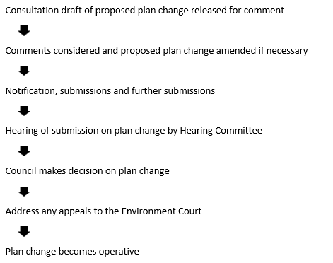
Process