Arrow River Catchment

Be part of the discussion about the future of water in the Arrow and Wakatipu Basin area.

The Arrow River catchment and the Wakatipu Basin aquifers form part of the Dunstan Rohe. A lot of work has already been done with this community on values and objectives as part of the process to manage water in the river and Basin.

We want to build on the great work the community did in recent years to establish values for the Arrow River catchment and Wakatipu Basin aquifers.

You said you treasure the Arrow’s amenity values: the clear water, scenic surrounds and recreational opportunities. You also identified the need for a reliable, good quality supply of water for community and irrigation use, which when taken, does not degrade the river’s natural values.

As part of the Water Plan review, we came back to the Arrow catchment community in 2019 to find out if the values previously identified were still relevant, and whether any community members had new values to add. Read the results of this consultation here.


Arrow River meeting 2021

Thanks to everyone who came along to the public meetings we held on 17 March about how we propose to manage the flow of freshwater in the Arrow River catchment.

You can view the meeting presentation here.

The preferred option discussed seeks to provide for the needs and aspirations of the community while taking an important first step towards meeting ORC’s obligations under the government’s new National Policy Statement for Freshwater.

Under the National Policy Statement for Freshwater, ORC must manage water via areas called Freshwater Management Units (FMUs). FMUs need to be areas that the council considers appropriate for managing water.

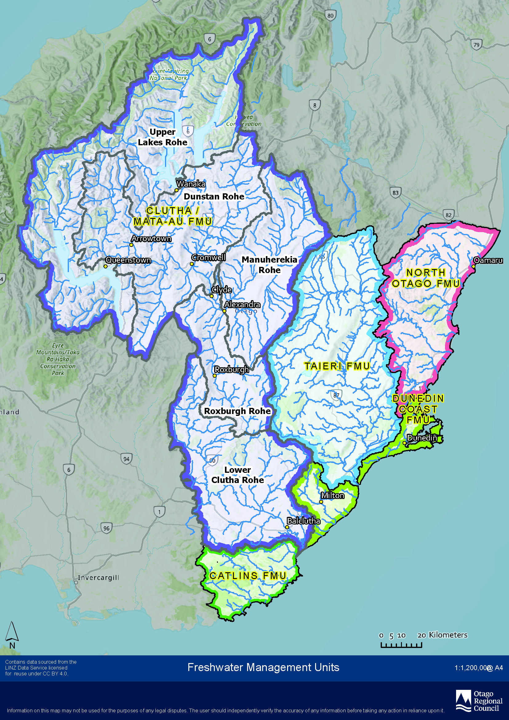
Otago has five draft FMUs which are North Otago FMU, Dunedin Coast FMU, Catlins FMU, Taieri FMU and the Clutha Mata-au FMU. The Clutha Mata-au FMU is further divided into five smaller areas called “rohe” (Maori for “area”) due to size. The rohe are: Upper Lakes Rohe, Dunstan Rohe, Manuherekia Rohe, Roxburgh Rohe and Lower Clutha Rohe as shown in the map below. The Arrow River catchment is in the Dunstan Rohe area.

The preferred option for managing water quantity outlined at the meetings will go on to be part of the Dunstan Rohe chapter of the new Land and Water Regional Plan for Otago. You will be able to have your say on this in 2023 by making a submission when the new plan is notified.

If you’d like to stay up-to-date on this project and other water-related projects, sign up to our monthly e-newsletter at www.orc.govt.nz/on-stream 

Background technical reports:

Arrow Habitat Analysis by Richard Allibone, WATER WAYS CONSULTING LIMITED

Cultural Value Report Arrow and Cardrona

Arrow Catchment Hydrology  NIWA provided the Otago Regional Council with the raw data used in preparation of this report. If you wish to see it, contact us.

Report on Flow Options for Arrow River and Wakatipu Basin Aquifers – Assessment against Kāi Tahu Values, March 2018

Archive

We are taking a new approach to deliver minimum flow water plan changes to the Arrow, Manuherikia and Upper Cardrona catchments. Up to this point, we have been consulting with the community on these plan changes on an individual catchment basis. The new approach will see ORC bring this work together to notify a single plan change.

You can see all the current information on the Minimum Flow plan changes on our 'Your Say' site - http://yoursay.orc.govt.nz 

Otago Regional Council is developing a change to Otago’s Regional Water Plan (Water Plan) to manage water in the Arrow catchment and Wakatipu Basin aquifers. 

The purpose of this plan change is to set minimum flows and water allocation limits for the Arrow catchment and to manage the amount of water in the nine Wakatipu Basin aquifers.

The proposed plan change is required by the National Policy Statement on Freshwater Management (the NPSFM).  The NPSFM requires council to set environmental flows and/or levels for all freshwater management units within its region. The Water Plan makes provision for the setting of minimum flows and allocation limits on rivers within a catchment and the setting of allocation limits and restriction levels for water in aquifers.

The changes we make to the Water Plan will be informed by the NPSFM, by environmental, economic, cultural, social, and planning assessments, and with input from the community and people affected by any potential changes.

Before we notify the proposed plan change to the Water Plan, we will be holding a series of community consultation sessions.  The feedback we receive from the community will help us to develop the plan change.

Following initial community consultation in June and the feedback received, we developed options for managing water in the catchment and aquifers, and consulted on these options in December 2017.  We held three information sessions in Arrowtown and Frankton, and sought feedback up until the 26 January 2018.

A summary of the feedback we received at the consultation sessions and during the feedback period is provided below.

Arrow Catchment and Wakatipu Basin aquifers Summary of Feedback - Consultation January 2018

In June 2017 we started the first of three stages of public consultation which help shape the development of the plan change for the Arrow catchment and Wakatipu Basin aquifers Integrated Water Management.  We asked people to identify what they value about water in the catchment and what was important to them.  A summary of the feedback received at the consultation sessions and during the feedback period is provided below.

Arrow catchment and Wakatipu Basin aquifers Summary of Feedback – Consultation June 2017 (834 KB)

Consultation Information:

Back to top
Online Maps & Data: