El Niño is a naturally occurring climate pattern that begins in the tropical Pacific Ocean and can influence Otago’s weather for several months. Unlike a hot summer, which often describes only temperature, El Niño can affect wind, rainfall and temperature. It may bring wetter and windier conditions to western Otago and hotter, windier and drier conditions to central and eastern areas, although every event is different, and heavy rainfall can still occur.
A significant El Niño event is forecast to develop later this year, potentially affecting Otago from late spring into summer. This does not mean drought or water shortages are certain, but preparing early can give households, businesses and rural communities more options if conditions become challenging.
Observed Central Pacific Sea Surface Temperature values
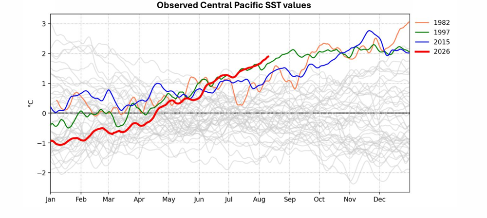
Source: Earth Sciences
Every El Niño event is different. A long-range forecast indicates an increased likelihood of certain conditions, but it cannot tell us exactly what weather each part of Otago will experience.
In previous strong El Niño years, western areas near the Southern Alps have tended to experience wetter and windier conditions. Central and eastern Otago have tended to experience hotter, windier and drier conditions. Periods of heavy rainfall can still occur, even where conditions are generally dry.
*Please note that historical El Niño patterns are a possible indication on what we might expect but it doesn’t mean this is exactly what this El Niño will bring.
El Niño is a naturally occurring climate pattern that can influence New Zealand’s rainfall, wind and temperature.
Possible effects in Otago include:
hotter, windier and drier conditions in some areas
wetter and windier conditions in western areas
periods of lower rainfall and reduced soil moisture
low river and stream flows
pressure on community, household and farm water supplies
increased demand for irrigation and stock water
an increased risk of wildfire
isolated heavy rainfall events
effects on farms, homes, businesses and infrastructure.
Note: These effects will not necessarily occur everywhere or at the same time. Conditions can vary significantly between catchments and across the region. Past historical El Niño events are a good indication of what to expect but these do not mean you will experience the exact same conditions in your area during this event.
AREA | EXPECTED CONDITIONS | KEY IMPLICATION |
|---|---|---|
Upper Lakes | Persistently wetter, with snowpack top-ups into late spring | Headwater impacts most likely; urban effects depend on individual events |
Dunstan | Rain mainly focused on headwaters; trending drier east of the Pisa Range | Highly variable temperatures and uneven rainfall across the area |
Manuherikia & Roxburgh | Strongest dry signal, with limited rain from southwest or northwest systems | Greater risk of soil-moisture stress and highly variable temperatures |
Taieri, Dunedin & Coast | Useful rain mainly from stronger southwesterly systems | Watch for thundery changes; onshore rain remains difficult to anticipate |
North Otago | Most passing fronts likely to bring little rain | Dryness may build; thunderstorms are the main localised weather risk |
Lower Clutha & Catlins | Frequent wet, and at times thundery, west to southwest fronts | Cooler daytime temperatures and periodic wet conditions |
El Niño forecasts and local conditions will continue to evolve over the remainder of 2026 and into 2027.
Use trusted sources and regularly check:
River and stream flows << this is a document do be downloaded? link doesn't work
ORC will continue to monitor rainfall, river flows and other environmental conditions across Otago and provide relevant regional information as conditions develop through the channels and online monthly water outlook updates.

Te puka ārahi kaiahuwhenua Farmers Guide
Here are the rules that apply to farming activities, with information on when you might need a resource consent, useful links, relevant dates and answers to frequently asked questions.

The Forestry Guide
Here are the rules that apply to plantation and permanent forestry activities, with information on when you might need a resource consent, useful links, relevant dates and answers to frequently asked questions.

The Developer's Guide
Here are rules that apply to development activities, with information on when you might need a resource consent, useful links, relevant dates and answers to frequently asked questions.
Preparing early does not mean severe conditions are certain. It means thinking ahead so that important decisions do not need to be made for the first time under pressure.
Households, businesses, farmers and landowners can:
consider how an extended dry period could affect water supplies
understand which water restrictions could apply
check essential water systems and repair leaks
refresh emergency and business continuity plans
identify important decisions and the conditions that would trigger them
monitor official forecasts and local environmental information
discuss plans with family, staff, neighbours and trusted advisors
seek advice or assistance early if it is needed.
Plans should be reviewed as forecasts and local conditions change.
Dry vegetation, low soil moisture, high temperatures and strong winds can increase wildfire risk.
Rural properties can prepare by:
removing dry grass and other flammable material from around buildings and infrastructure
maintaining suitable fire breaks
checking access for emergency vehicles
checking firefighting equipment
considering water availability for firefighting
using lower-flammability plants near buildings and planted shade areas
monitoring fire danger and restrictions.
Before lighting any outdoor fire, check the current requirements through https://www.checkitsalright.nz.

Households and businesses can also prepare for changing weather and possible water shortages.
Practical actions include:
checking taps, toilets, pipes and tanks for leaks
using water carefully before shortages occur
understanding local water-restriction levels
reviewing emergency and business continuity plans
refreshing emergency supplies
considering how people, pets and other animals would be supported
identifying alternatives if a private water supply runs low
checking in with neighbours, whānau and people who may need assistance.
A household emergency kit should include food, drinking water, torches and a battery-powered radio. Other items may include essential medicines, hygiene supplies, pet supplies and phone-charging options.
City and district councils generally manage reticulated community drinking-water supplies and restrictions. People should check their city or district council’s website for information about their local supply and any restrictions.
Extended dry conditions and adverse weather can create practical, financial and personal pressure.
Stay connected with staff, neighbours and whānau. Sharing local experiences can help, particularly for people who have not previously managed through an El Niño event or an extended dry period.
MPI recommends talking with trusted advisors, including veterinarians, farm advisers, banks, accountants and sector organisations. It also encourages farmers to make time for themselves, staff and family, and to ask for help when needed. [9974-El-ni...rochure-v5 | PDF]
Farmers and growers who are unsure where to start can contact the below organisations for support.
Otago Regional Council
Freephone - 0800 474 082
Phone - 03 474 0827
Email: customerservices@orc.govt.nz.
Online: online contact us form
MPI’s On Farm Support team
Phone: 0800 707 133
Email: onfarmsupport@mpi.govt.nz
Rural Support Trust
Phone: 0800 787 254
Online: Contact | Rural Support Trust NZ
Not quite. El Niño is not simply another name for a hot summer. It can change patterns of wind and rainfall as well as temperature, and its effects can vary across Otago. ORC (and other organisations) are sharing information now, so people understand the increased likelihood of dry, windy or wet conditions and have time to prepare, rather than because any particular outcome is certain.
No. El Niño can increase the likelihood of dry conditions in parts of Otago, but drought is not certain.
Conditions will depend on the amount and timing of rainfall, temperature, wind, soil moisture, water demand and how long dry periods last, if you live in an area that has historically been impacted by droughts, keep a close eye on the latest information as it comes available to ensure you are prepared.
No. Conditions can vary considerably across the region.
During previous strong El Niño events, western areas near the Alps have tended to be wetter and windier. Central and eastern Otago have tended to be hotter, windier and drier.
People should follow information relevant to their own catchment/area, district and water source.
Yes. Heavy rainfall and other severe weather can still occur during an El Niño event, including in places experiencing generally dry conditions.
Continue to follow forecasts and weather warnings and maintain preparations for a range of conditions.
Early preparation provides more options if conditions become difficult.
Simple actions such as repairing leaks, checking water systems, updating farm and emergency plans, and identifying decision points can reduce pressure later. These actions can also be useful during other dry or severe weather events.
Possibly. Restrictions will depend on local conditions and the type of water supply and this will be an evolving situation over the remainder of 2026 and start of 2027.
Restrictions may apply to:
reticulated town or community water supplies
irrigation water
water takes subject to minimum flows
private supplies affected by reduced availability.
City and district councils generally manage restrictions on reticulated community supplies. ORC manages regional water resources and monitors compliance with water permits and minimum-flow conditions.
ORC provides environmental monitoring information for locations across Otago.
Water permit holders should make sure they are checking the monitoring location and minimum-flow information relevant to their permit.
More information here: River and stream flows
Assess the supply early and identify a suitable backup before water levels become critical.
Check for leaks or equipment problems, monitor use and consider how long the available supply will last. Alternative drinking water must be safe for its intended use.
Start with normal requirements for each animal class, then allow for higher consumption during hot and dry weather.
MPI provides the following indicative figures for normal water consumption:
Animal class | Indicative normal water use |
Cattle | 45 litres per head per day |
Sheep and goats | 4 litres per head per day |
Red deer | 5 litres per head per day |
Horses | 30 litres per head per day |
Alpacas | 7 litres per head per day |
Pigs | 20 litres per head per day |
Poultry | 0.2 litres per bird per day |
MPI advises that animals may drink up to three times their usual quantity in some conditions, particularly when eating dry feed or when working, pregnant or lactating. [9974-El-ni...rochure-v5 | PDF]
Check that the source, pumps, storage, pipes and troughs can meet likely peak demand.
Move affected animals to an appropriate shaded area, make clean water readily available and seek prompt advice from a veterinarian or appropriately qualified animal-health professional.
Signs vary between species, so use species-specific guidance rather than relying on a single general checklist.
A forecast alone does not mean every farm should reduce livestock numbers.
Farmers should use their own feed, water, animal, financial and seasonal information. MPI recommends maintaining a feed budget, identifying decision points and acting early if a deficit is forecast. [9974-El-ni...rochure-v5 | PDF]
ORC recommends to discuss options in preparation for El Nino with trusted rural advisers, livestock agents and processors who know your specific situation and farm.
A few things you can do now
Refresh household and business emergency plans.
Check water sources, storage, pumps, pipes and troughs.
Repair irrigation and stock-water leaks.
Review feed, livestock and financial plans.
Identify decision points and discuss them with trusted advisers.
Consider peak animal water demand and alternative supplies.
Reduce flammable vegetation around buildings.
Monitor official forecasts and local conditions.
Stay connected and ask for help early.
El Niño forecasts and local conditions will continue to evolve over the remainder of 2026 and into 2027.
Use trusted sources and regularly check:
River and stream flows << this is a document do be downloaded? link doesn't work
ORC will continue to monitor rainfall, river flows and other environmental conditions across Otago and provide relevant regional information as conditions develop through the channels and online monthly water outlook updates.


