
Lifejackets must be worn on ALL recreational craft 6 metres or less in length.
Learn moreLifejackets must be worn on ALL recreational craft 6 metres or less in length.
Otago's four deep high-country lakes—Wānaka, Hāwea, Whakatipu / Wakatipu and Waiwhakaata / Lake Hayes— sit at the foot of the Southern Alps in remarkable landscapes carved by massive glaciers. They are a significant part of the headwaters of the Clutha/Mata-au river, New Zealand’s largest catchment by both area and water volume.
These lakes are rare on a global scale, with extraordinary depths shaped by ancient glaciers. Whakatipu / Wakatipu plunges to around 400 metres, with its deepest point lying about 80 metres below sea level.
Not just spectacular landscapes, these lakes are complex freshwater systems and important water reservoirs, supporting diverse species and ecosystems. By looking from the surface to the deepest parts of the water, we can better understand how these lakes function, detect changes in their health and make informed decisions about their future.
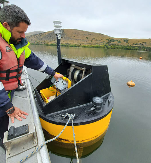
As part of ORC's ongoing State of the Environment monitoring, we monitor the lakes in several ways to understand their health and identify any changes over time. This includes:
Monitoring buoys that record lake conditions throughout the day
Monthly water quality testing from the lake’s surface to the lakebed
Monitoring lake snow — a sticky material that can form in lake water
Surveying underwater plants to assess lake health
Testing rivers and streams that flow into and out of the lakes
Monitoring plants and animals living in and around the lakes
Scientific research to better understand the lakes and how they are changing
Long-term monitoring is important because lake conditions can be affected by land-use change, pollution and short- and long-term climate conditions.
The data we collect helps to:
identify early signs of degradation
understand natural changes in the lakes
assess the effectiveness of restoration work
improve lake and catchment management
support future climate change modelling and research.
ORC's monitoring buoy network provides detailed information about lake conditions, from the surface down to a maximum depth of 120 metres.
The first high-frequency monitoring buoy was installed in Lake Hayes in 2019. Two more were installed in Lake Whakatipu and Lake Wānaka in 2022, followed by a buoy in Lake Hāwea in 2026.
The buoys help us understand important lake processes, including:
Oxygen levels and whether they are becoming too low for aquatic life
Algal growth, which can indicate changes in water quality
Sediment movement, including when mud and other material from the lakebed are stirred into the water
Water clarity, including changes that make the water clearer or cloudier
This information helps us detect changes in lake health early, understand what may be causing them, and decide whether further investigation or action is needed.

Lake Whakatipu buoy being deployed in November 2022

Lake Whakatipu buoy being deployed in November 2022

Lake Whakatipu buoy being deployed in November 2022

Lake Whakatipu buoy being deployed in November 2022

Buoy fully deployed in Lake Whakatipu, November 2022


The buoys measure a range of physical, chemical and biological conditions in the lake, including:
Water temperature – showing how the lake warms, cools and mixes over time.
Dissolved oxygen – indicating how much oxygen is available for aquatic life.
Chlorophyll – providing an indication of the amount of algae in the water.
Phycocyanin – helping detect the presence of cyanobacteria (blue-green algae).
Turbidity – showing how clear or cloudy the water is.
pH – indicating how acidic or alkaline the water is.
Conductivity – helping identify changes in dissolved salts and other substances in the water.
Weather conditions – including air temperature, wind, humidity and sunlight, which can influence conditions within the lake.
Together, these measurements help us track changes in water quality, understand what may be affecting lake health and identify potential problems early.
The buoys currently take measurements at different depths between four and eight times each day. During each check, sensors move down through the lake, recording how conditions change from the surface to the deeper water.

Lake Hāwea deep lakes water monitoring buoy - installed August 2026.

Lake Hāwea with water monitoring buoy.

Lake Hāwea water monitoring buoy.

Limnotrack illustration showing the water monitoring buoy deployed.


The depth of monitoring varies between lakes and the type of data being collected.
Deeper monitoring is important because the thermocline — the layer where water temperature changes rapidly — can occur well below 70 metres in the larger lakes.
Lake Hayes: The buoy can monitor the full depth of the lake, which is about 33 metres.
Lakes Whakatipu and Wānaka: The buoys currently collect the full range of water quality measurements down to 70 metres. However, temperature and dissolved oxygen can be measured down to 120 metres. ORC is working to extend the other measurements to 120 metres as well, so that all parameters can eventually be measured to this depth.
Lake Hāwea: Current monitoring capability allows all measurements to be collected down to 120 metres.
The installation of the Hāwea buoy marks the completion of ORC's deep-lake monitoring buoy network. However, it does not mark the end of the wider deep lakes programme.
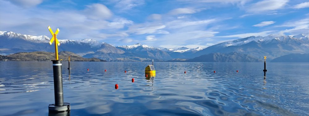
The sensors on the buoys do not always reach the deepest parts of the lakes. To fill this gap, ORC places additional sensors deeper in the water, including close to the lakebed. These sensors measure water temperature and oxygen levels. This is important because the deepest water can lose oxygen, which can affect aquatic life and release nutrients from lakebed sediment.
Once a month, ORC also lower a water-quality instrument from the surface to near the lakebed. It measures temperature, oxygen, water clarity, conductivity, and chlorophyll (algae) at different depths.
Together, these methods let us see what’s happening throughout the lake — from the surface right down to the deepest water — giving us a clearer picture of how these complex ecosystems are changing over time.
ORC publishes near-real-time buoy data through the Environmental Data Portal.
The interactive dashboard provides access to the latest data from the high-frequency monitoring buoys in Lakes Wānaka, Hayes, Whakatipu and Hāwea.
The data provides an up-to-date view of how these lakes are behaving and the pressures they may be experiencing.
In 2024, ORC established the Otago Deep Water Lakes Technical Advisory Group. The group brings together scientists and technical experts with knowledge of deep lakes and freshwater ecosystems, with a focus on lakes Wānaka, Whakatipu and Hāwea. Its role is to:
review what scientific information is already available about the lakes
identify important questions that existing information cannot answer
recommend monitoring and research to help answer those questions
provide scientific advice to support the future management of the lakes.
The group supports a coordinated approach to understanding the deep lakes and the pressures they may face.


