The governance report titled Head of Lake Whakatipu floodplain and liquefaction hazard intervention assessments written by ORC’s Natural Hazards Analyst Tim van Woerden and Manager Natural Hazards Jean-Luc Payan, will go to Councillors for consideration in the Safety and Resilience Committee tomorrow in Dunedin.
Councillors will also have new report by Tonkin + Taylor Ltd; Head of Lake Whakatipu Hazards Adaptation; Engineering approaches for managing liquefaction-related risk, dated February 2023. That report follows a November report on adaptation approaches for flooding hazards on the Dart-Rees floodplain, supplied by Damwatch Engineering.
The reports are the first to assess potential hazard management approaches for liquefaction and floodplain hazards specific to the Glenorchy township and Dart-Rees floodplain area.
The information is designed to help inform the community, ORC and the Queenstown Lakes District Council in the development of natural hazards adaptation approaches. This will be the focus of the next community engagement sessions in Glenorchy with dates yet to be confirmed.
The Tonkin + Taylor report identifies a range of potential liquefaction hazard management interventions for Glenorchy township only, an area which has been identified as having a high likelihood of liquefaction occurring following an earthquake.
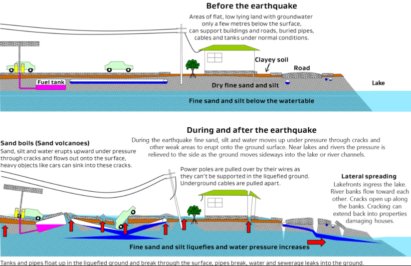
It provides a high-level assessment of potential mitigation approaches including a review of the key benefits and constraints of those approaches, to help understand the range of available interventions for liquefaction-prone areas in and around Glenorchy.
The approaches assessed range from widespread geotechnical improvements for large land areas, to strengthening or retrofitting existing building foundations or piling and concrete slabs for new buildings. The report notes the most robust options may be too impractical and unaffordable, while the least robust options may not meet building consent standards.
The reports are for the Safety and Resilience Committee to “note” the proposed scope and intent of the Head of Lake Whakatipu natural hazards work programme and help inform natural hazard management and adaptation for decision-making, in the future.
As with the earlier report by Damwatch Engineering, it identifies a range of potential hazard management interventions, and reviews the key benefits and constraints of those approaches.
The report to Council does not recommend any decisions at this time.
The reports are intended to help ORC, QLDC, and the local community understand potential engineering approaches or interventions for managing the liquefaction and flooding hazards identified in Glenorchy and in the Dart-Rees floodplain area.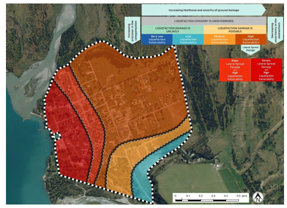
Liquefaction vulnerability of Glenorchy township, mapped by Tonkin + Taylor (2022)
The earlier Damwatch Engineering report: Dart-Rees Floodplain Adaptation - Report on 23-24 February 2022 Workshop
