Storm surge
A storm surge is the rise in sea level generated by a storm, measured as the height of the water above the normal predicted astronomical tide.
The low atmospheric pressure and persistent winds associated with a storm can cause large amounts of seawater to be pushed onshore, flooding roads and coastal property and causing significant erosion damage.
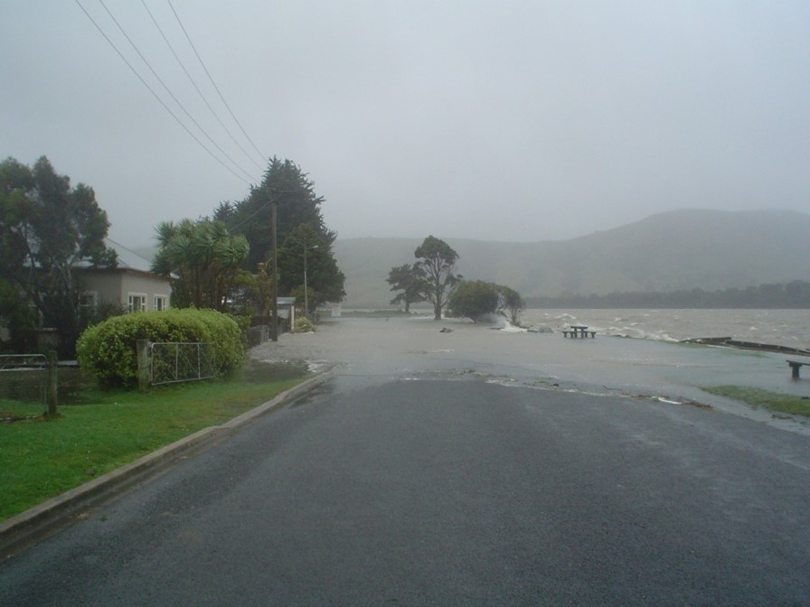
Storm surge affecting Pounawea, April 2006. Photo: Mike Hilton (University of Otago)
- Astronomical tides are the periodic rise and fall of ocean waters driven by the attraction of the moon and sun and cycle about every 12 hours. The maximum tidal range along the Otago coast is approximately 2.5 metres, making it an important aspect in storm surge and related high sea levels events.
- Wave set-up and wave run-up can further elevate sea level and the size of a storm surge. Wave set-up is the increase in the average level of the sea due to the effect of waves. Wave run-up is the increase in sea level from waves breaking in the foreshore zone. The increase corresponds to each respective wave, so the effects of wave run-up occur over short periods. Since breaking waves are reduced in sheltered areas such as inlets, wave run-up is generally restricted to open coast sites.
We have modelled the depth and extent of storm surge flooding for 17 places along the Otago coast:
- Tautuku
- Papatowai
- The Catlins
- Kākā Point
- Clutha River/Mata-Au Delta
- Toko Mouth
- Taieri Mouth
- Brighton
- Kaikorai (Kaikarae)
- South Dunedin
- Long Beach and Pūrākaunui
- Blueskin Bay
- Karitāne and Waikouaiti
- Moeraki
- Hampden
- Kākaunui/Kakanui and Taranui
- Ōamaru
Other settlements and unpopulated stretches/areas along the Otago coast are also potentially subject to storm surge hazard, however we do not yet have sufficient information to model storm surge in these locations.
Climate Change is expected to increase the frequency and magnitude of storm events at our coasts. This may affect the severity of storm surge impacts along our coastlines and exacerbate storm surge and related hazards in our coastal communities.

Glossary
Low atmospheric pressure: Where the pressure within the earth’s atmosphere is lower, compared to surrounding locations nearby.
Storm surge return period: Estimated time between storm surge events of a certain size.
Foreshore zone: the part of the land next to the sea that is between the limits reached by high and low tide.
Publications
A range of other information and documents provides relevant information on storm surge hazards, including publications below.
A 2008 NIWA report, “Otago Regional Council Storm Surge Modelling Study”, shows storm surge extents for return periods of 20, 50, 100 and 500 years with three increments of sea level rise (MHWS, 30cms and 50 cms) for 17 locations along the Otago coastline. This report is referenced in the natural hazards database.
There is also an older 2005 NIWA report entitled ‘Otago Extreme Sea Level Analysis’, commissions by ORC, to determine extreme sea levels with return periods of 2, 5, 10, 20, 50 and 100 years for eight locations along the Otago coastline.
The eight locations are:
- Ōamaru
- Kākaunui/Kakanui River Mouth
- Shag Point
- Otago Heads (Spit Jetty)
- Otago Harbour (Port of Dunedin)
- Taieri River mouth
- Clutha River mouth
- Catlins River mouth
The focus is on extreme sea levels to be used as ocean boundary conditions for river flood modelling.
An ORC report titled 'Community vulnerability to elevated sea level and coastal tsunami events in Otago' assesses the level of vulnerability (rather than the risk) at a number of communities along the Otago coastline. An updated assessment of coastal hazard for the Dunedin District was completed in 2014.
The Otago coastline extends 480km from Chaslands in the south to the mouth of the Waitaki River in the north.
Approximately 124,000 people (64% of Otago’s population) live within five kilometres of this coastline. A number of the communities situated along the coast have a level of hazard exposure to elevated sea level (or storm surge) and tsunami events.

July 2012
PDF | 2 MB
The report draws on tsunami and storm surge modelling undertaken by National Institute of Water and Atmosphere (NIWA) for the Otago Regional Council (ORC) in 2007/08, coastal topography data and local knowledge of each community. This information has been used to assess how people and the communities in which they live would be affected during credible, high magnitude tsunami and elevated sea level events.
July 2012
PDF | 8 MB
June 2014
PDF | 7 MB