On Thursday night, MetService lifted its southern orange heavy rain and wind warnings, and red wind warnings, after the heavy rainfall in the Otago headwaters eased early earlier in the afternoon.
ORC’s General Manager Science and Resilience Tom Dyer says the flows of most Otago rivers peaked on Thursday morning, and lake level rises had now slowed.
“Some rain remains in the Otago forecast for today, it’s below the MetService watch and warning criteria, but due to current conditions, we’ll continue to monitor all river and lake flows and the lower Clutha catchment, including through the long weekend,” Mr Dyer says.
Mr Dyer cautions that lakes levels have the potential to increase further from the forecast rain on Monday, depending on the nature of the event, but it’s too early to quantify the extent.
“As the lake levels are already elevated, we’ll maintain a continuous watch on flows and lake levels,” Mr Dyer says.
Lake Whakatipu is predicted to remain steady or increase slightly with levels predicted to reach 311.1m-311.3m on Saturday morning. It’s expected Lake Whakatipu will begin to inundate Rees and Beach streets through the stormwater system when the lake level is about 311.3m. Precautionary sandbagging is already in place along parts of the foreshore.
Lake Wanaka is predicted to remain steady or increase slightly with levels predicted to reach 279.2m-279.4m on Saturday morning, with some inundation of the lake reserve land expected. This predicted lake level is about 600mm lower than the lower sections of nearby Ardmore Street.
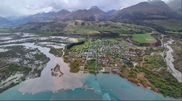
The level of Glenorchy Lagoon is predicted to increase again late tonight/early Saturday morning, but the level is not likely to exceed the overtopping threshold of the Glenorchy floodbank.
“However, some low-lying parts of Glenorchy, and also Kingston township foreshore, could begin to be affected,” Mr Dyer says.
MetService forecast for Monday
A complex trough of low pressure from over the Tasman Sea moves onto the country, bringing significant weather to many places, including snow to relatively low levels over the east of the South Island. There is moderate confidence of heavy rain about western Tasman, Buller, Grey, northern Westland and central and northern parts of the Canterbury High Country. There is low confidence of significant heavy rain about eastern and Central Otago and Canterbury. In addition, there is also low confidence of heavy snow down to 500 metres for Central Otago and the Canterbury high country.

Flooding in Otago
ORC monitors rainfall, lake levels and river flows, using MetService forecasts along with our own data and expertise, we model the predicted effects of heavy rainfall. This page will be updated when we see potential rise in lake levels.

NZTA road conditions
Use this map to get live updates of road conditions in Otago

Lake level flood information
Quick link to find the flood information on lakes in Otago.

QLDC Facebook
Follow Queenstown-Lakes District Council for updates via Facebook.