The portal will collate data from more than 250 water monitoring sites around Otago and replaces the existing flood and low flow warning sites currently available on ORC’s website.
The new system will give people access to a user-friendly map which includes improved context of what is happening across the region, plus the ability to view and download historical data.
In some cases that means people will be able to easily access up to 80 years of data says ORC’s Manager of Regulatory Data and Systems, Simon Wilson.
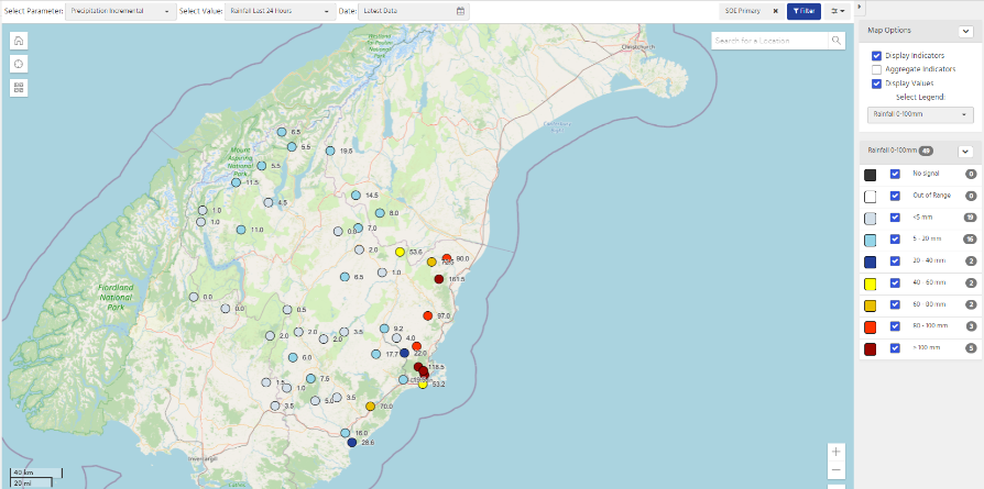
“We know the current website is well used, particularly during flood events. The new portal will provide a much better at-a-glance picture of what’s happening throughout Otago.”
Mr Wilson says the portal will also provide access to a much greater range of information beyond the standard river flow and rainfall sites. Data available includes a range of water quality parameters such a E-Coli.
“ORC’s Environmental Monitoring Team collects a huge amount of data from across the region which is used to track the health of Otago’s environment.”
“One of our goals in setting up the portal was to make that information much more accessible to the public. We’ve started by publishing some key water quality measures and will be adding more data over time,” he says.
ORC will continue to run both the current website and the new system until the older web pages are switched off later in 2023.
“We encourage those who use the current website to transition to the new system by beginning to familiarise themselves with the portal now. The ability to access more comprehensive, up-to-date data, combined with an improved interface, means a much better user experience for people needing information on rainfall and river flow or levels,” says Mr Wilson.
The environmental data portal contains a comprehensive user guide, in the form of a downloadable PDF, plus a video guide.
Free webinars explaining how to use the portal will be run on 7 March at 3pm and 7pm. Members of the public are invited to sign up to a webinar of their choice.
ORC’s Environmental Monitoring team will also be offering demonstrations onsite at the Wānaka A&P Show on 10 and 11 March.