Coastal survey of Molyneux Bay starts shortly – ORC
Monday 30 June 2025
We are about to begin a bathymetric coastal survey in Molyneux Bay to observe seafloor elevations of transects of the 6500-year-old “sand wedge” made up of sediment from the Clutha – Mata Au River.
ORC’s Natural Hazards Analyst, Julion Wright, says the survey is to determine the current dimensions of the coastal Clutha “sand wedge” deposit, which ultimately spills river sediment into the Southern Ocean.
“The sand wedge deposit’s an important part of the South Otago sediment system, containing a large volume of sediment that may, or may not be, contributing to the stability of the coast,” he says.
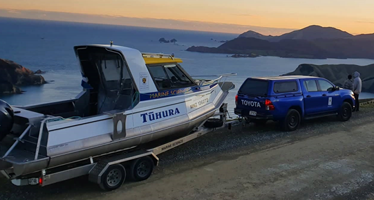
Data gathering . . . the University of Otago’s Research Vessel RV Tūhura
The ‘modern’ sediment of the wedge is formed by deposits of material from the Clutha River over the last 6500 years.
“This survey will be compared to a similar ORC survey from 2013 to map any changes in the sand wedge deposit. The results of this will have future implications for coastal and river management in South Otago,” Mr Wright says.
Those future implications could potentially include a better understanding of sediment accumulation and movement, as well as river mouth and coastal erosion effects, he says.
Molyneux Bay is just south of Balclutha township and encompasses the mouth of the Clutha Mata Au River, down to the Nugget Point lighthouse, which is south of Kaka Point township.
The offshore survey will be conducted by Geomatics NZ and use a single-beam echo sounder mounted on the University of Otago’s Marine Science vessel, RV Tūhura*. The 6.5m vessel will not be streaming any devices astern, and over a week is expected to travel about 180 kilometres within Molyneux Bay (map below).
The survey is scheduled for July, but the timing is otherwise entirely weather-dependent. Mr Wright says the shallower part of the sand wedge is influenced by discharges from the Clutha as well as coastal processes.
The offshore surveying will also be extended onshore with land surveying techniques to cover the coastal morphology (shape and structure); the gap between the onshore and offshore surveys having already been covered by an earlier 2025 airborne bathymetric LiDAR survey (Light Detection and Ranging).
Once the survey is complete, it will take up to three weeks to process the raw data, to form 2D imagery, which will then be analysed to interpret what changes may, or may not, have occurred since the previous survey in 2013. The results will then be made publicly available.
Survey area within Molyneux Bay
*The university’s RV Tūhura is described as 6.5 m aluminium powerboat for up to six people. It can support restricted oceanographic work, limited bottom sampling, trawling and diving, for operations around coastal Otago and inland South Island waterways. (Source: University of Otago).