-
-
-
-
-
Debris Flood Hazard Information and History
-
-
-
-
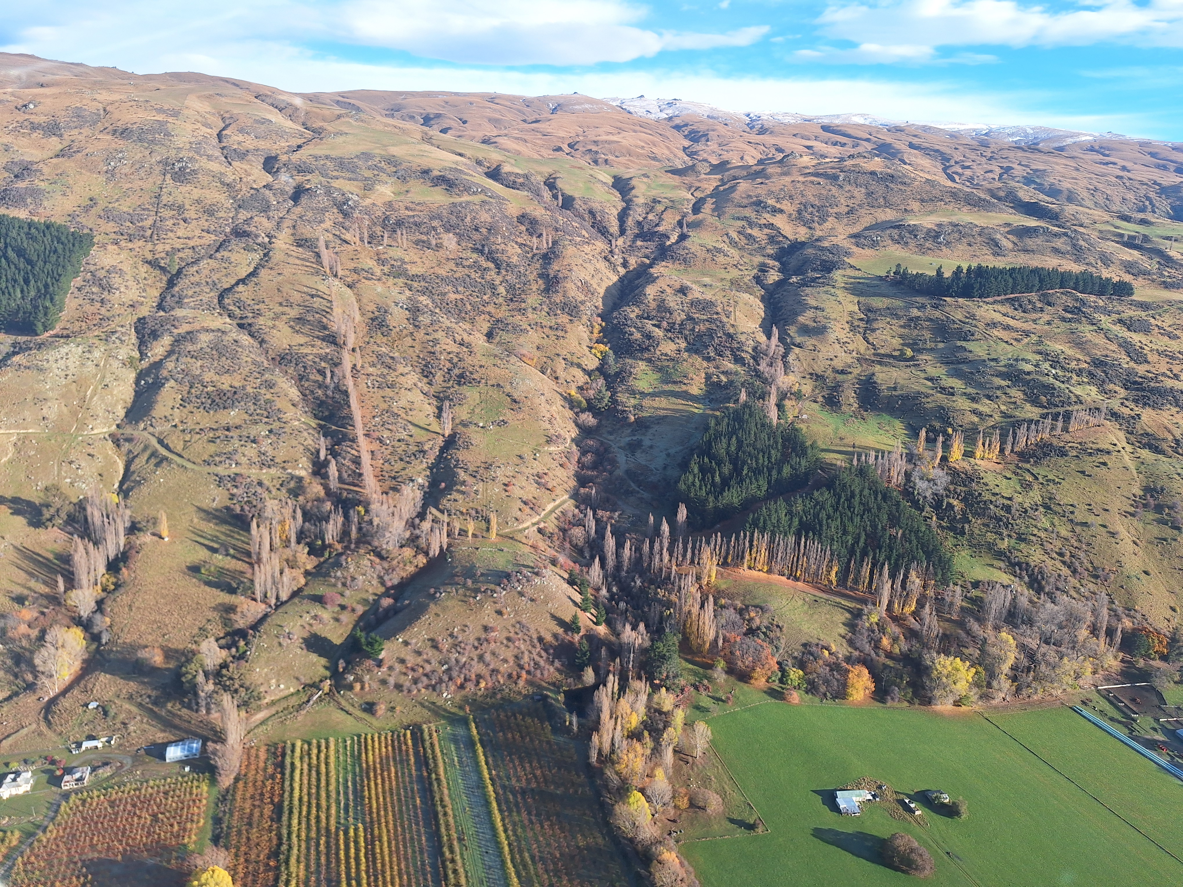
Roxburgh is known for its strong sense of community, commitment to safety and stunning natural landscapes. The orchards, rolling hills, river and surrounding ranges are all part of what makes this area unique.
But living close to steep hills and fast-flowing streams means the Roxburgh community can face natural hazards. These can vary from stream (fluvial) floods which are mostly comprised of water, to debris flows (mostly sediment and debris with smaller amounts of water) and debris floods (roughly equal amounts of water and debris).
These types of events are triggered mainly by very heavy rainfall (such as from severe thunderstorms), with the floodwater picking up loose material in the catchment and channel and moving it downstream. There may also be contributions from other factors (such as rapid snowmelt or landslides).
Our latest risk assessment specifically studied debris floods, as this hazard is thought to be more likely in the area.
Debris flows are fast-moving flows of water and debris that can cause harm to people, property and infrastructure if they reach developed areas. They can move quickly and with great force.
Fluvial floods are mostly water. These are when small riverlets, streams or rivers burst into life in a thunderstorm or heavy rain event. The sudden surge of water can be devastating.
A debris flood is similar to a debris flow, but with more water and less debris.
When do debris flows or floods happen?
These types of events are triggered mainly by very heavy rainfall (such as from severe thunderstorms), with the floodwater picking up loose material in the catchment and channel and moving it downstream.
There may also be contributions from other factors (such as rapid snowmelt or landslides).
Local insight
Reservoir Creek, Black Jacks Creek and some other creeks have had debris flood in recent years, including the event in 2017.
Quick fact
Heavy rain from thunderstorms is the most common cause of debris floods in Roxburgh.
To understand why debris floods are a risk in Roxburgh, it helps to know about alluvial fans.
Alluvial fans are landforms built up over time by material washing down from the hills. The diagram below shows an alluvial fan:
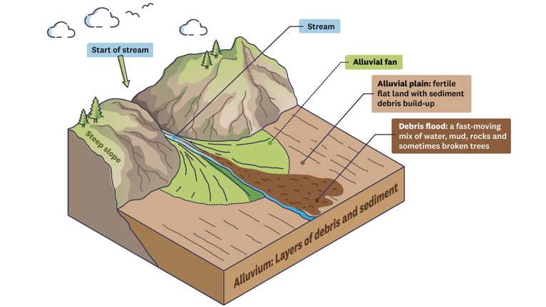
An alluvial fan is formed when:
- Streams and creeks flow down steep hills, they carry rocks, gravel, sand and soil.
- The water reaches flat land, it slows down and drops this material.
- Over many floods and heavy rain events, the material spreads out in a fan shape. This spread of rock and sediment what we call an alluvial fan.
The shape of the land and the type of rock in the Old Man Range and the hills, west of the Clutha River, produce a lot of loose material.
The creeks that run down the eastern side of the Old Man Range carry a lot of loose soil and rock, and their catchments (the areas where rainwater gathers and flows into streams or creeks) are small and steep.
This means that during heavy rain, water can pick up this material quickly, creating powerful flows that travel downstream and cause damage to everything in their path.
Debris flows and debris floods have been recorded in the Roxburgh area since at least 1938, some have caused major disruption.
In the past, these events have swept into parts of the township, damaging homes, roads and important services like power and water.
The table below summarises key hazard events:
| Date | Catchments | Key triggers and impacts |
| 1938 | Slaughterhouse Creek and several adjacent catchments |
|
| 1978 | Reservoir Creek, Black Jacks Creek, Pumpstation Creek, and Slaughterhouse Creek |
|
| 1993 | Slaughterhouse Creek, Pumpstation Creek |
|
| 2015 | Black Jacks Creek |
|
| 2017 | Pumpstation, Reservoir, Golfcourse, Black Jacks; Stevensons Creek (no direct impact) |
|


Several agencies have worked together over the years to manage and reduce debris flow and flood risks in Roxburgh.
The current Roxburgh debris flood hazard management programme involves three technical projects to help manage and understand the debris floods:
The interim creek monitoring and maintenance plan (ongoing). The purpose of this plan is to keep the creeks clear and working properly so they can effectively carry floodwaters during a debris flow or flood event.
The Roxburgh debris flood detailed hazard and risk study (completed).
Teviot Valley Debris Flood Risk Management Optioneering (in progress).
The table below summarises the key work by Otago Regional Council (ORC), Central Otago District Council (CODC), New Zealand Transport Agency Waka Kotahi (NZTA), Civil Defence emergency Management Otago (CDEM) and other stakeholders:
Nu. | Actions and objectives | Timeframe | Responsible agency |
|---|---|---|---|
1 | Built a concrete chute along a section of Reservoir Creek. | Early 1980s | Otago Catchment Board |
2 | Conducted regional-scale alluvial fan hazards mapping with more detail for the Roxburgh area. | 2009 | ORC |
3 | Commissioned GNS Science to carry out preliminary debris flow hazard assessments. | 2017 | ORC |
4 | Conducted a series of mitigation works to remove the excess sediment deposited by, and since, the 2017 events, as well as some channel armouring. These included emergency works immediately following the 2017 events in addition to further works since the events. | 2017–present | ORC |
5 | Installed a rain gauge to monitor rainfall. | 2018 | ORC |
6 | Commissioned Golder to carry out two further investigations to provide preliminary geomorphic mapping, culvert capacity calculations, and risk-to-life estimate and a review of possible hazard mitigation concepts for further study. | 2019 | ORC |
7 | Implementation of an Interim Channel Monitoring and Maintenance Plan to maintain the capacity of the five creeks (Stephensons, Black Jacks, Golfcourse, Reservoir and Pumpstation) to convey high flows during a debris flow event. | On-going | ORC |
8 | Undertook helicopter surveys and flew LiDAR and aerial imagery. | 2019, 2022, 2024 | ORC |
9 | Upgraded the SH8 culverts at Pumpstation, Golfcourse, and Black Jacks Creeks. | 2021–2023 | NZTA |
10 | Installed Otago weather radar. | 2020 | MetService |
11 | Rain radar tool implemented. | 2023 | ORC |
12 | Roxburgh Community Response Group established. | 2024 | CRG |
13 | Emergency management training and planning. | Ongoing | CDEM |
14 | Roxburgh Debris Flood Study 2026 | 2026 | ORC |
15 | Teviot Valley Debris Flood Risk Management Optioneering | In progress | ORC |
Debris flood hazard in the Roxburgh area is managed by several organisations, each with different roles and responsibilities:
- Otago Regional Council (ORC) is responsible for 24/7 flood monitoring, which includes notifying Civil Defence Emergency Management (CDEM) of high-risk weather forecasts for the Roxburgh area and rainfall monitoring.
- ORC is responsible for managing five creeks (Stephensons, Black Jacks, Golf Course, Reservoir and Pumpstation) and undertaking necessary works.
- ORC conducts technical investigations to understand debris flood hazards and ways to manage their impacts.
- Central Otago District Council (CODC) oversees land use and spatial planning, local roads management and Three Waters, as well as owns and maintains the concrete chute at Reservoir Creek.
- New Zealand Transport Agency Waka Kotahi (NZTA) is responsible for State Highway 8 (SH8) maintenance and management as infrastructure provider. NZTA works with ORC to monitor the debris flood impacts on State Highway crossings following flood events. NZTA will also carry out necessary works such as removal of debris and structure repair when and if needed.
- CDEM is responsible for regional emergency management planning and leading the '4Rs' (reduction, readiness, response and recovery). CDEM will work in support of the local emergency services (Police, Fire, Hato Hone St John) and will lead if a State of Local Emergency is declared.
- CDEM will continue to build capacity for the established community networks to assist with emergencies in the Roxburgh and Miller's Flat areas.
- Community Response Group (CRG) prepares a Community Resilience Guide (with CDEM support) to support the Roxburgh community before, during and after an emergency. CRG also helps communities become more prepared and resilient to disasters. It has the ability to work autonomously in a crisis by using pre-planning to establish a safe Community Emergency Hub and operate it.