An alluvial fan is a build-up of river or stream (alluvial) sediments that form where streams emerge from hill country and onto a valley floor.
Alluvial fans can be attractive places to live because they are elevated and have good drainage. However, because they are steeper than river floodplains, they are prone to both flooding and other gravity-driven hazards, like landslides, which can cause serious damage to buildings and pose a threat to life.
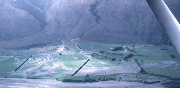
During rainstorm events, water and/or sediment can overtop the stream channel and spread out across the fan surface. Large amounts of fast-moving water, rocks, boulders and tree debris can be carried at great speed beyond the stream channel, presenting a significant risk to any people, property or infrastructure in their way.
Some of these main hazards are described below:
Fluvial floods – Characterized by the transport of large amounts of water, and comparatively smaller amounts of fine sediments (mud to small stones and rocks).
Debris floods – Rapid surge of water mixed with roughly equal amounts of debris (mud, silt, rocks to small boulders, sticks, trees).
Debris flows – Viscous mixtures of sediment and debris (mud to sand, rocks and large boulders mixed with woody debris such as trees) which can travel much faster than a conventional stream flow water flood.
Channel erosion – Where floodwaters and sediment flows eat away at the stream channel margins, increasing the chances of avulsion (where floodwaters, sediment and debris break out from the stream channel unexpectedly and form new channels on the fan surface).
Climate change is expected to bring more frequent and intense rainstorms to the stream catchments that feed alluvial fans. In the upper parts of these catchments, an increase in natural processes such as landslides, rock and debris avalanches may cause more sediment to be transported the fans downstream, exacerbating the risk of natural hazards on them.
Please visit the ORC Climate Change section for more information on climate change in Otago.
The Alluvial Fans tab in the Natural Hazards Database (NHDB) Portal will allow you to view our mapped information for alluvial fans in Otago.
You can find other information and documents about alluvial fan hazards in our Natural Hazards reports & publications page. In particular, a 2008 scientific paper — ‘Principles of Sustainable Development on Fans’ by Davies and McSaveney — looks at the need to understand the hazards associated with alluvial fans so these features can be developed sustainably.

Te hurika o te āhuaraki Climate change
Earth experiences natural changes in its climate, but the rate of these changes is increasing. The impacts we observe today are the result of historical emissions, and increases in emissions in recent decades will lead to significant changes in the coming years.

Otago Natural Hazards Database
Our hazards database is intended to improve public access to hazard information and to help the public, local authorities, and others make informed decisions about their exposure to natural hazards.

Pūroko me kā Tuhika Reports and publications - natural hazards
A natural hazard is a situation where a natural event has the potential to cause harm or loss. Informed by science, ORC shares our research into managing natural hazards in Otago.