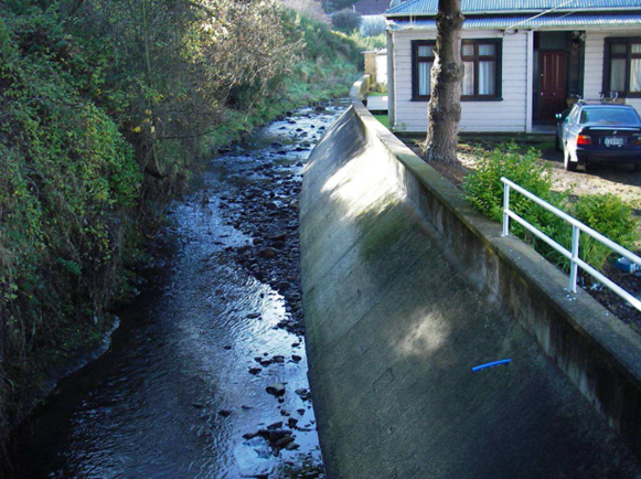
Lindsay Creek near Otago Community Hospice with normal levels Sep 2026
Lindsay Creek, in North East Valley, is surrounded by a vibrant urban population. This project helps develop understanding around the potential flood risk, improve preparedness and encourage awareness.

Wednesday, 21 October 2026
North East Valley Bowling Club
Drop-in Session: 3:00–6:00 pm (come anytime)
Community Presentation and Q&A: 6:30–7:30 pm
Stay for informal chats and refreshments until 8:30 pm
North East Valley has a long history of flooding, with significant flood events recorded since the 1860s, including in 1868, 1912, 1923, 1929, 1991, 2006 and 2015. Over the years, ORC has investigated flooding in the Lindsay Creek catchment and considered different approaches to managing flood risk.
You can learn more about the previous work done in the Lindsay Creek catchment in the timeline summary.
Today, ORC also carries out ongoing maintenance, monitoring, and flood forecasting to inform a flood response during heavy rainfall events.
The current Lindsay Creek Flood Risk Reduction Programme was launched in 2024 to take a fresh look at the problem.
The new 2026 flood hazard study gives ORC, DCC, emergency management agencies and the community better information about flooding from Lindsay Creek so we can work together to increase community resilience.
The next stage of investigation is to develop a Flood Risk Reduction Plan for the Lindsay Creek catchment. Past flood protection options will be re-examined, as well as a fresh look at new options. Future investment will be considered as part of ORC Long Term Plan (2027-37) deliberations.
There will be plenty of opportunities during this process for you to have your say.
Lindsay Creek rises on the flanks of Mount Cargill and runs southwest, draining North East Valley and joining the Water of Leith at the Botanic Garden. Most of the stormwater network in North East Valley discharges into Lindsay Creek. The catchment is compact (about 12 kilometres squared), with a short main channel (about 7 kilometres long). Some sections of Lindsay Creek channel are relatively narrow (sometimes only a few metres wide).
The steep and compact catchment results in the flood peak reaching urbanised areas quickly (less than two hours from the onset of heavy rain), leaving limited ability for residents and emergency services to plan a response during a heavy rainfall event.
During flood events, Lindsay Creek can overflow its channel and flood adjoining low-lying land. There is also a risk that the steep sider of the catchment may produce debris or landslides which may block the waterway and obstruct structures such as bridges and culverts.
During heavy rainfall events, high water levels in Lindsay Creek will prevent the free discharge of the stormwater network. Stormwater overflows contribute to surface flooding and can compound the effects of river flooding.

1912 Flooding, Lindsay Creek, looking down Blacks Rd to North Rd

22 September 1971 Water of Leith Approx. 1500Hrs. Lindsays Creek from Glendining Avenue

22 September 1971 Water of Leith Approx. 1500Hrs. Lindsays Creek from Glendining Avenue

25 Feb 1986 flooding. Water of Leith — Lindsay Creek. 1.00 pm

25 Feb 1986 flooding. Water of Leith — Lindsay Creek. 5.30pm

12 January 2002 flooding — Lindsay Creek at North Road Bridge.

12 January 2002 flooding — Lindsay Creek at North Road Bridge.

12 January 2002 flooding — Lindsay Creek at North Road Bridge.

12 Jan 2002 flooding — Lindsay Creek at Quarry Gardens

12 Jan 2002 flooding — Lindsay Creek at Quarry Gardens

12 Jan 2002 flooding — Lindsay Creek at Quarry Gardens

12 Jan 2002 flooding — Lindsay Creek at Quarry Gardens

12 Jan 2002 flooding — Lindsay Creek at Quarry Gardens

12 Jan 2002 flooding — Lindsay Creek at Quarry Gardens

July 2017 flooding — Lindsay Creek


October 2026
PDF | 4 MB

August 2026
PDF | 13 MB
This flood study provides a comprehensive revision and update of existing information regarding the presence, extent, and severity of flood hazards within the Lindsay Creek catchment. The information contained within this study is intended to assist with planning, risk awareness, and the development of strategies that promote responsible management of flood-prone areas.

October 2026
PDF | 577 KB
An overview of ORC approaches to flood management and mitigation for Lindsay Creek from 1995 to now.
The Lindsay Creek Flood Hazard Study provides a comprehensive update of existing information regarding the extent and severity of river flood hazards within the Lindsay Creek catchment and North East Valley. It refines our understanding of potential flood risks and provides updated detailed flood hazard information that can support Council and communities in making informed decisions and implementing effective floodplain management practices. This work will inform the flood risk reduction investigations and the emergency flood responses.
The investigation used hydrological analysis and hydraulic modelling to improve understanding of the Lindsay Creek flood hazard. The investigation focused on river flooding, with some consideration of the influence of stormwater. It considered a range of flood flows, including the effects of a ‘maximum credible’ event and of climate change.
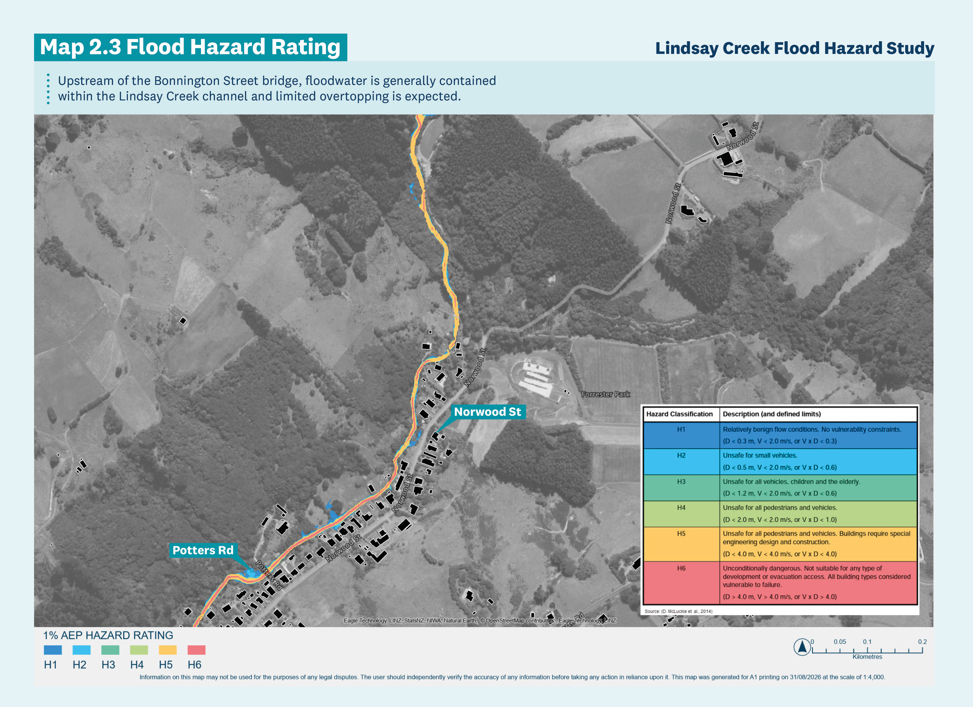
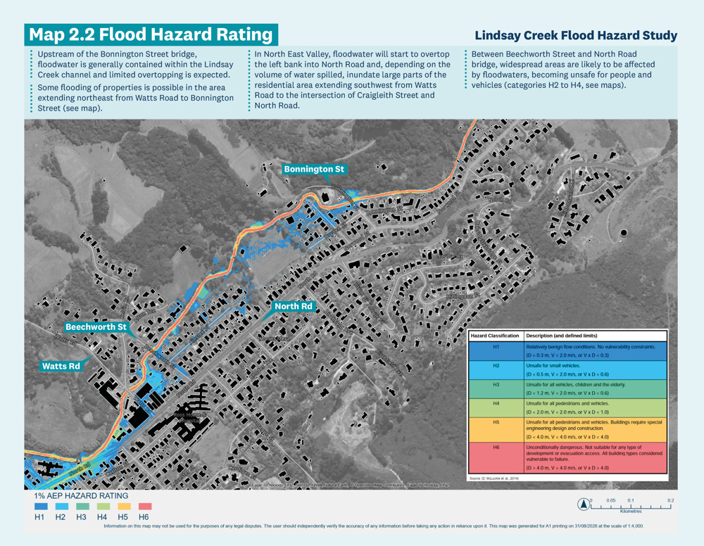
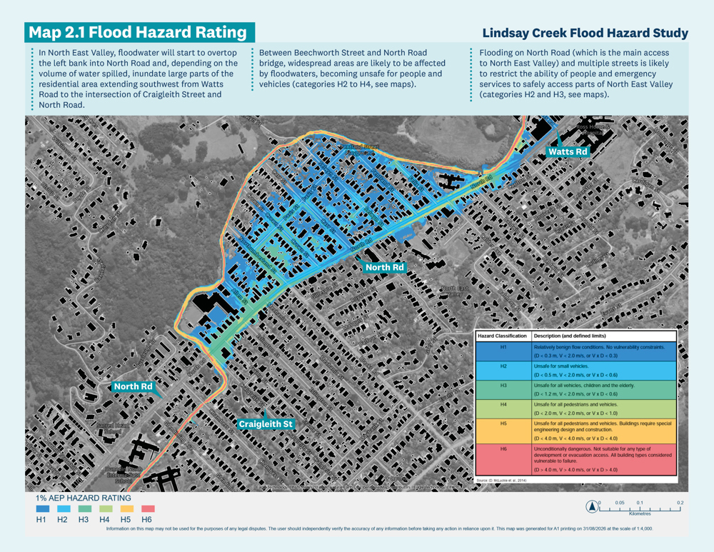
Flood hazard is assessed by considering the combined effects of floodwater depth and flow velocity, recognising that the severity of the hazard to people, vehicles, and structures is influenced by both the depth of inundation and the speed or velocity at which floodwaters are moving. While shallow, slow-moving water generally presents a lower hazard, increasing depths and velocities can increase the potential for instability, structural damage, and risk to life.
During flood events, Lindsay Creek can overflow its channel and flood adjoining low-lying land in North East Valley. The extent of flooding and its characteristics vary with the size of flood event.
The effects of the 1% Annual Exceedance Probability (AEP) flood are shown and described in the following pages. The 1% AEP flood refers to a flood event that has a 1% chance of occurring in any given year, also known as a ‘100-year flood’.
Flooding in areas with the lowest flood hazard category (H1, see maps) is not likely to affect people’s safety, vehicle access and building structural stability because it is likely to be shallow and slow moving. However, flooding of buildings and internal damages and loss of property can still occur. This depends on the building floor level and local features, such as fences, affecting the overland flow paths locally.
Flooding on North Road (which is the main access to North East Valley) and multiple streets is likely to restrict the ability of people and emergency services to safely access parts of North East Valley (categories H2 and H3, see maps).
Most flooding identified in the new flood hazard investigation is unlikely to cause structural damage to buildings. The areas where the hazard categories are the highest (impact on building structural stability, categories H5 and H6) are within and adjacent to the creek channels and in local pockets of deeper or faster floodwaters along the North Road corridor, in particular in the vicinity of the intersection between North Road and Baldwin Street (see maps).
For a ‘maximum credible’ flood event, the floodwater is likely to affect larger parts of the areas between Bonnington Street and the North Road bridge and to start to affect properties along North Road from North Road Bridge to Opoho Road and the Botanic Gardens (mainly in the lower flood hazard category). Larger sections of North Road and many surrounding streets are likely to be impassable, possibly with more damage to North Road near the intersection with Baldwin Street.
The report should be considered as one component of a broader flood risk assessment framework rather than a definitive statement of flood risk for any individual property.
The results represent the predicted flood behaviour based on the available topographic, hydrological and hydraulic information, and the catchment conditions that existed at the time the study was undertaken. Flood hazard mapping should therefore be regarded as a representation of current conditions rather than a permanent depiction of flood hazard.
The investigation is primarily intended to inform the development of a flood risk reduction plan, and it is not intended or suitable to assess flood hazard for individual properties or for property insurance purposes.
Future changes to land use, development, stormwater infrastructure, channel conditions, climate, or the availability of improved datasets may influence flood behaviour and may mean revision of the mapping and associated hazard information.
The assessment does not include a detailed representation of the existing stormwater drainage network.
All flood modelling is subject to uncertainty arising from assumptions relating to rainfall, hydrology, hydraulic model parameters, topographic data, channel conditions and future catchment changes.
The updated flood hazard results will now help with:
improved understanding of potential flood risks for ORC, Dunedin City Council (DCC), emergency management agencies and the community
supporting ORC and communities in making informed decisions and implementing effective floodplain management practices
informing the ORC Lindsay Creek flood risk reduction programme
planning, risk awareness, and the development of strategies that promote responsible management of flood-prone areas.
ORC presented a comprehensive Leith–Lindsay Flood Protection Scheme that included Lindsay Creek and a scaled–back version to Council in 2011 and 2013, respectively. Council decided not to pursue either version of the scheme for Lindsay Creek. The decisions were informed by the economic climate at the time, feedback from community consultation, and the potential impact of costs on residents versus . the benefits provided by the proposed work. Since then, ORC has carried out ongoing maintenance, monitoring, and flood forecasting to inform a flood response during heavy rainfall events.
The current Lindsay Creek Flood Risk Reduction Programme was launched in 2024 to take a fresh look at the problem. You can learn more about the previous work done in the Lindsay Creek catchment in the timeline summary.
Previous work by ORC identified the floodplain flood hazard area that may be affected if floodwater is able to overtop the main channel for Lindsay Creek. The mapped ‘2GP’ flood hazard was created in June 2014 as part of the ORC report ‘Flood Hazard of Dunedin’s Urban Streams’ to inform the DCC District Plan (2GP) and has been updated since (2018) to account for changes discussed during and after the DCC 2GP hearing (April 2017). A geomorphological approach was used as the basis for identifying land that may be affected by inundation. The geomorphological approach is appropriate for Lindsay Creek as it is an urban stream with a high potential for blockages that can activate the floodplain.
The approach taken to identifying flood hazard areas was to identify the relevant geomorphic floodplain associated with the Lindsay Creek using detailed topographical information. The geomorphic floodplain is the natural landform created by the creeks when they are in flood, or the area occupied by the creek before the creek was confined or incised to its present course. Typically, the geomorphic floodplain comprises low-gradient planar landforms adjacent to the river extending to the break in slope at the base of the adjacent hillslope. The mapped areas are intended to represent an envelope of areas that may be affected by overflow (i.e. flow exiting the main channels) under a range of flood scenarios (magnitudes, channel blockages, timing of inputs), rather than an area liable to be fully inundated in any one event.
The 2026 flood hazard assessment uses a hydraulic modelling approach to produce detailed flood hazard information for specific flood scenarios.
The two approaches are complementary, and the information should be considered together.
A sensitivity-based approach has been adopted to represent the potential effects of climate change on flood flows. A 20% increase has been applied to the peak design discharges used as inflows to the hydraulic model. This adjustment is intended to represent a plausible increase in flood magnitude associated with projected increases in extreme rainfall intensity and is applied as a sensitivity allowance rather than as a definitive prediction of future flood behaviour.
At this stage of the programme (flood hazard assessment), the adopted 20% increase is considered appropriate for the Lindsay Creek catchment given its rainfall-driven flood response characteristics. The uncertainty associated with this simplified approach is recognised. Therefore, a catchment-specific climate-adjusted assessment will be completed during the design phases of potential flood mitigation work. This assessment will inform the nature and scale of the mitigation work and provide transparency about climate assumptions for decision makers.
As part of earlier flood protection planning for Lindsay Creek, ORC entered into a range of property arrangements with affected landowners. These included whole-property acquisitions, partial land acquisitions and access agreements.
As the proposed flood protection approach changed, the land required for the works was reassessed. In 2013, ORC’s Engineering and Hazards Committee decided that properties no longer required for Lindsay Creek management should be disposed of. Some historical property arrangements and agreements remain in place today(Meeting Minute, ORC Safety and Resilience Committee, Resolution SRC24-115, 7 November 2024).
The current Lindsay Creek Flood Risk Reduction Programme is still at the investigation stage, and no preferred flood management option has been selected. Any future property requirements would depend on the flood management options considered and future Council decisions.
Flood hazard maps represent a snapshot of current catchment conditions and should be interpreted in conjunction with the accompanying technical information and an understanding of the underlying modelling assumptions. The report should therefore be considered as one component of a broader flood risk assessment framework rather than a definitive statement of flood risk for any individual property.
The investigation is primarily intended to inform the development of a flood risk reduction plan and it is not intended or suitable to assess flood hazard for individual properties or for property insurance purposes.
Insurance companies use a wide range of information when assessing risk, and hazard studies are one possible source of information used in those assessments. Insurers generally assess risk based on the expected cost of providing insurance over the next year, not long-term climate scenarios, and focus on physical property damage rather than life safety risk.
ORC does not make decisions about insurance cover or premiums. Questions about individual insurance policies should be discussed directly with insurance providers or brokers.
The new flood information does not mean that people are required to move from their homes or businesses. The 2026 flood hazard study provides updated information about flooding from Lindsay Creek; it does not make decisions about individual properties or recommend that people relocate. The information will help inform future discussions about how flood risk in the Lindsay Creek catchment could be managed.
Most flooding identified in the new flood hazard study is unlikely to cause structural damage to buildings. The highest hazard areas that may be unsafe for structures are within and adjacent to the creek channels and in local pockets of deeper or faster floodwaters along the North Road corridor.
If you are concerned about possible flood impacts, you may want to consider ways that your household or business can reduce flood damage (such as flood proofing) and increase awareness and resilience (such as flood action plans).
See further resources on flood risk reduction at: https://www.civildefence.govt.nz/guidance-training/consistent-messages/flood/reduction-reduce-the-impacts-of-floods
The 2026 flood hazard study itself does not make decisions about future development. The updated flood information can, however, be used to help inform land-use planning and decisions about development in areas affected by flood hazards.
Floodwater can create safety risks for people and vehicles during flood events.
During a flood event, you should:
stay away from creek channels and adjacent areas, as this is where the deepest and fastest flooding is expected
avoid entering or driving through floodwater — even shallow floodwater can make road conditions unsafe and difficult to judge
stay informed through official emergency management updates
follow advice from emergency services and Civil Defence Emergency Management (CDEM), including any advice about evacuation or safe locations.
If your house or business is located within a flood-prone area, it is also recommended that you get ready before flooding occurs. Resources are available here: https://getready.govt.nz/emergency/floods.
More information about flood preparedness and safety is available from Civil Defence Emergency Management (CDEM) (https://www.otagocdem.govt.nz/).
If there is an immediate risk to life or safety, contact emergency services by calling 111.
The 2026 flood hazard study gives ORC, DCC, emergency management agencies and the community better information about flooding from Lindsay Creek. We can now work together to increase community resilience.
The next stage of investigation is to develop a Flood Risk Reduction Plan for the Lindsay Creek catchment. Past flood protection options will be re-examined, and a fresh look will be taken at other options. Future investment will be considered as part of ORC Long-Term Plan (2027-37) deliberations.
Keep your eye out for opportunities to have your say.
Community feedback and local knowledge are important parts of understanding how flooding may occur in the Lindsay Creek catchment.
If you have questions about the new flood information, or information about previous flooding that you would like to share with ORC, please contact us:
Phone: 0800 474 082
Email: customerservices@orc.govt.nz
More information is also available through the ORC Natural Hazards Data Portal, where hazard mapping can be searched by address or location: orc.govt.nz/portal
Otago Regional Council (ORC) is holding a community drop-in session and a presentation to:
share the key findings of the 2026 Lindsay Creek flood hazard study,
provide an update on the Lindsay Creek Flood Risk Reduction Programme and outline the next steps,
invite feedback on the flood hazard study, new flood information and next steps.
Staff from ORC and Civil Defence Emergency Management (CDEM) will be present at these sessions to hear your concerns or provide further information.
When: Wednesday, 21 October 2026
Where: North East Valley Bowling Club, 139 North Road, North East Valley
3:00–6:00 pm
Come anytime, stay as long as you like
Explore detailed flood hazard maps
Chat (one-on-one or in a group) with staff from ORC and CDEM
6:30–7:30 pm
Stay for informal chats and refreshments until 8.30pm