
Consultation has now closed on how the Lower Clutha and Lower Taieri flood protection and drainage costs are shared in your community.
Consultation on proposed changes to how Lower Clutha/Mata-Au and Lower Taieri flood protection and drainage scheme costs are shared closed at 11.59pm on Friday 25 September 2026.
Thank you to everyone who took the time to make a submission. Council will now consider the feedback received as part of the next stages of the rating model review.
Public hearings are expected to be held in November 2026 for submitters who asked to speak to their submission. Following the hearings, Council will consider submissions and other relevant information before deciding whether to adopt the proposed changes.
We are working on making submissions publicly available here. Please check back soon to view submissions.
Any changes to rates would not take effect until 1 July 2027, if approved through the Long-Term Plan 2027–37 process.
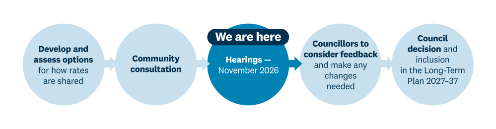
Public hearings – November 2026
Submitters who asked to speak to their submission will have the opportunity to speak at a public hearing.
Council considers submissions
Council will consider the submissions received, hearing information and other relevant evidence.
Council decision
Council will decide whether to adopt the proposed changes to the rating model.
Long-Term Plan 2027–37
If changes are approved, the new rating approach will be incorporated into the Long-Term Plan 2027–37.
New rates – from 1 July 2027
Any changes to rates would take effect from 1 July 2027.
The proposed changes to how flood protection and drainage scheme costs are shared may affect your property’s rates in different ways.
Depending on factors such as the level of flood protection received, land use, drainage demand and proposed scheme boundaries, you may:
pay a higher targeted rate
pay a lower targeted rate
begin paying a targeted rate
no longer pay a targeted rate
have your property included in or removed from a scheme boundary.
During engagement on Otago Regional Council's Long-Term Plan 2024–34, members of the community raised concerns about how the costs of flood protection and drainage schemes are shared. In response, Council resolved to review the current rating model.
The Lower Clutha/Mata-Au and Lower Taieri Flood Protection and Drainage Scheme Rating Model Review looks at how the costs of the schemes are shared between the properties that benefit from them.
The current rating approach has developed over many years and includes historical arrangements that can be difficult to understand and explain. Following a detailed review, Council is proposing a new approach that is intended to be fairer, more transparent and easier to understand.
The proposal focuses on how the costs of the schemes are shared between properties.
The preferred approach separates flood protection and drainage because they provide different benefits and are driven by different costs.
Flood protection costs would be shared based on the level of flood protection benefit each property receives.
Generally, properties protected from larger flood events would contribute a greater share than those receiving lower levels of protection.
Drainage costs would be shared based on:
land area
land use
the relative drainage demands different land uses create.
This better reflects how properties place different demands on the drainage network.
Check out the rates estimator below to compare your property's 2025–2026 targeted rates with the proposed 2027-2028 rates.
Click the arrow on the bottom right  to expand to full view. This estimator is best viewed on a computer.
Please also note that it is an indication only and does not account for property revaluations in the last 12 months. Some address records may be incomplete. If you can’t find your address, try searching by valuation number — this can be found in your property’s rates information on your local council’s website.
The rates estimator only includes properties in either the current or proposed scheme boundaries.
See something that doesn't make sense or you are not getting a result?
Call 0800 474 082 or email: customerservices@orc.govt.nz
Why are you using 2025–2026 rates in your estimator and not the new ones I’ve just received?
The modelling has been done over the last six months, so it was practical to use the 2025–26 rates.
Does your rates estimator take shifts in valuations over the last 12 months into account?
No, it is based on the 2025–26 rates and is to be used as a guide only. If approved by Council after consultation, new rates would be set as part of the Long-Term Plan 2027–37 and won’t come into effect until 1 July 2027.
I live in a new subdivision/property that isn’t in your estimator — how do I know what I could be paying?
If your property isn't listed, you can still use the interactive map to see whether it falls within a proposed flood protection or drainage scheme and the level of flood protection proposed for your area. This will help you understand how the proposed rating approach may apply.
If you'd like more specific information about your property, including a rates estimation, please contact us on 0800 474 082 or email customerservices@orc.govt.nz, and our staff can help explain how the proposal may affect you.
Why am I getting a warning message on my rates estimate?
A warning message means we've identified something about your property that may affect the accuracy of the estimated rates. This could be because:
Your property intersects a scheme or benefit zone boundary. We’ve estimated the portion of your property that falls within each benefit zone. In these cases, the exact extent may require further review.
Some information about your property was missing from the source data. We’ve estimated the missing information to provide a rates estimate.
Your property was missing from the source data. It has been manually assessed to ensure it is included.
If anything about your property's result doesn't look right, or you believe the estimate may be incorrect, please contact us on 0800 474 082 or customerservices@orc.govt.nz.
Are the rates shown in the estimator my final rates?
No. The estimator provides an indicative estimate only. If Council adopts the proposal following consultation, rates will be set as part of the Long-Term Plan 2027–37.
As part of the review, we've updated the proposed scheme boundaries using the latest flood modelling, benefit zone and drainage information.
Different areas receive different levels of flood protection. Engineers use flood modelling to estimate the level of flood protection the scheme provides to different areas.
Properties protected from larger, less frequent floods receive a greater benefit from the scheme than properties that are only protected from smaller, more frequent floods.
Floods are often described by their likelihood of occurring in any given year. For example:
A 10-year flood has a 10% chance of occurring in any given year (more frequent smaller floods).
A 100-year flood has a 1% chance, or less, of occurring in any given year (less frequent larger floods).
These terms don't mean a flood will only happen once every 10 or 100 years. A 100-year flood could happen more than once in a short period or not occur for more than 100 years. The numbers simply describe the likelihood of a flood of that size occurring in any one year.
Under the proposed rating model, properties that receive a higher level of flood protection would pay a higher targeted rate, reflecting the greater benefit they receive from the scheme.
Note: benefit zones are also referred to as ARI (average recurrence interval) bands in the Statement of Proposal found below in Further information
The amount of stormwater runoff a property produces varies depending on the size of the property and how it’s used.
Factors such as the type of land use; hard surfaces such as roofs, driveways and car parks; and the level of benefit a property receives from the drainage scheme are used to determine each property’s contribution to drainage pressures.
Properties that place greater demands on the drainage network are allocated a higher share of the scheme’s costs.
Land use type | Estimated runoff |
|---|---|
Business | High |
Residential | Medium |
Lifestyle | Medium |
Rural | Low |
You can compare current and proposed scheme boundaries and see the flood protection benefit zones your property benefits from.

The Lower Taieri Plain has a long history of flooding, and development of drainage and flood protection works goes back to the early 1900s.

The East Taieri Drainage Scheme, divided by Silver Stream, directs northern drains to the Upper Ponding area and southern drains to the Lower Ponding area. Low Taieri River flow uses gravity drainage; high flows need pump stations.

The West Taieri Drainage Scheme, part of the Lower Taieri Flood Protection Scheme, is bordered by the Taieri River, Lake Waipori, and the West Taieri Contour Channel. Unlike other schemes, it relies entirely on pump stations at Waipori, Henley, and Lake Ascog due to its low elevation, often at or below sea level.

The Lower Clutha Delta Scheme mitigates flooding and drains 9,300 hectares from north of Balclutha to the sea. The Clutha River, splitting into Koau and Matau branches, and other water sources contribute to the flow
During engagement on ORC's Long-Term Plan 2024–34, members of the community raised concerns about how the costs of flood protection and drainage schemes are shared.
In response, Council resolved to review the current rating model to ensure rates are shared more fairly, are simpler to understand, and reflect the latest information about flood protection and drainage benefits.
This review is about how costs are shared, not about increasing the total amount collected from these schemes.
At the scheme level, no. We are not proposing to increase the total amount collected through these rates.
However, because the review is about how costs are shared, some property owners could pay more while others could pay less. The proposed approach is intended to better reflect the benefits each property receives from the scheme.
No. Your current year's rates (2026–2027) will not be affected.
If Council approves changes following the review, new rates would be set through the Long-Term Plan 2027–37 process and would not come into effect until 1 July 2027.
Consultation closed on 25 September 2026.
Council will first consider submissions and information presented at the public hearings, expected to be held in October 2026. Council will then consider the proposed rating model as part of the Long-Term Plan 2027–37 process.
Any changes to the rating model would not take effect until 1 July 2027.
We're consulting on how the costs of the flood protection and drainage schemes are shared between properties. We are not consulting on the level of service provided, whether the schemes should exist or the total cost of operating them.
Regardless of future local government arrangements, flood protection and drainage schemes will still need to be funded.
This review is about ensuring the rating system remains fair, transparent and fit for purpose into the future.
This review is about how costs are shared; not how much is collected overall.
Any future rates cap would affect potential increases in rates revenue but would not change the principles used to distribute costs among properties.
The Tokomairiro Drainage Scheme and Alexandra Flood Protection Scheme will be reviewed in future years.
The way rates have been shared in Lower Clutha has remained largely unchanged since the scheme was established in the 1970s.
This review provides an opportunity to ensure rates are based on current flood hazard information; land use and the benefits properties receive today.
Targeted rates help pay for specific services or infrastructure that benefit particular areas, such as floodbanks, pump stations and drainage networks.
Properties that receive benefits from these schemes contribute through targeted rates.
Targeted rates fund the operation, maintenance and renewal of flood protection and drainage infrastructure, including:
floodbanks and stopbanks
pump stations
drainage channels and drains
other flood protection assets.
A portion of the cost is also funded through general rates, recognising that flood protection and drainage schemes provide wider community and economic benefits.
A targeted rate is paid by properties that directly benefit from flood protection or drainage scheme assets such as stopbanks, pumps and drains.
A general rate is paid by a wider group of Otago ratepayers and helps fund flood protection services that provide broader community benefits.
Definition from ORC rates invoices:
General rates are made up of a rate assessed differently on capital values of land in each territorial authority city or district. An across-the-board annual general charge is a fixed amount for each property, funding air quality, governance and community activities, land sustainability, policy development, river and waterway management, safety and hazards, transport and water resources.
Lower Clutha, Tokomairiro, Lower Taieri, West and East Taieri drainage schemes have targeted rates for adopted classification lists, with each category in this list based on location of the rating units within scheme areas. Lower Clutha, Tokomairiro and Lower Taieri rates are calculated on capital values.
West and East Taieri rates are calculated on the area of land within each unit.
The Leith flood protection scheme’s targeted rate is set differently, based on the location of the rating units within the scheme area, and calculated on capital values. The indirect Leith Scheme is charged to all properties in the Dunedin district.
No.
Properties contribute differently depending on the benefit they receive from a flood protection scheme or the demands they place on a drainage scheme.
Under the proposed new rates, properties receiving higher levels of flood protection would generally pay more than those receiving lower levels of protection.
Flood protection schemes are designed to reduce flood risk from rivers and waterways and help protect people and their livelihoods. It is proposed that you will pay relative to the level of protection you receive.
Land drainage schemes are designed to provide ongoing, effective and reliable drainage of farmland. It is proposed that properties that have a higher impermeable surface area and therefore higher runoff into the drainage scheme will pay more.
We believe it is fair that properties contribute according to the level of flood protection they receive.
For example, a property protected during a larger flood event receives a greater benefit than a property protected only during smaller flood events.
Floods are often described by their likelihood of occurring in any given year. For example:
A 10-year flood has a 10% chance of occurring in any given year (more frequent smaller floods).
A 100-year flood has a 1% chance, or less, of occurring in any given year (less frequent larger floods).
These terms don't mean a flood will only happen once every 10 or 100 years. A 100-year flood could happen more than once in a short period or not occur for more than 100 years.
Under the proposed rating model, properties protected from larger flood events (such as a 100-year flood) receive a greater level of benefit from the scheme than properties protected from smaller flood events. As a result, it is proposed that these properties pay a higher targeted rate, reflecting the greater level of protection they receive.
During the development of the Long-Term Plan 2024–34, ORC consulted on introducing a consistent split between the costs funded by general rates and targeted rates for flood protection and drainage activities.
Following consultation, Council adopted a funding split of:
Flood protection: 20% funded through general rates and 80% through targeted rates.
Drainage: 10% funded through general rates and 90% through targeted rates.
The general rate component is collected from across the Otago region, while the targeted rate is paid by the properties that directly benefit from each scheme.
This approach recognises that while flood protection and drainage schemes provide direct benefits to the properties they protect, they also provide wider regional benefits. These include protecting regionally important infrastructure, such as State Highway 1, the rail network, Dunedin Airport, electricity infrastructure and other public assets, as well as supporting the wider regional economy and community resilience.
For this reason, Council determined that a portion of the costs should continue to be shared across the wider Otago region, with the remainder funded by the properties that receive the greatest direct benefit from each scheme.
You can read more about this decision on page 2 of the Long-Term Plan decisions following feedback.
You can use the online rates estimator on this page to compare your current rates with the proposed rating model.
We have looked at the boundaries of the scheme and have proposed changes using the latest flood mapping, benefit zones and drainage areas. This has resulted in changes to the boundaries — some properties that were previously rated as part of the scheme are now no longer included, while others that were not part of the scheme are now included and will be charged a targeted rate.
For some properties, the proposed changes may result in higher rates, while for others, rates may decrease. This will depend on factors such as the level of flood protection benefit received, land use, drainage demand and whether a property is included within the proposed scheme boundaries.
The latest assessment shows your property receives little or no direct benefit from the infrastructure funded by the targeted rate.
As a result, it may no longer be included within the proposed rating area.
The proposed boundaries reflect updated flood hazard information and a more accurate assessment of which properties benefit from the flood protection and drainage schemes.
The aim is to ensure costs are shared more fairly among those who benefit.
Some properties are only partially protected by the flood protection scheme or receive different levels of protection across the property.
Where part of a property receives protection and part does not or receives a different level of protection across different parts of the property, the proposed rating model reflects both levels of benefit/protection.
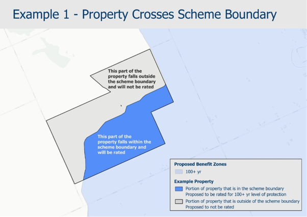
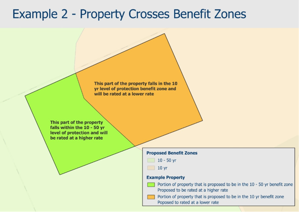
You can view flood hazard information using ORC's online hazard maps.
The Lower Taieri and Lower Clutha flood protection schemes are designed to reduce flood risk, not eliminate it completely.
These schemes protect communities from the more frequent and moderate flood events that would otherwise cause much greater damage. The stopbanks, pump stations, drainage networks, floodgates and retention areas help manage large volumes of water and significantly reduce the number of properties and roads that would flood without them.
However, there are several reasons why flooding can still occur:
Local rainfall can overwhelm drainage systems. Sometimes flooding is caused by intense rain falling directly on an area faster than drains and pumps can remove it, even when river levels remain within the scheme's design limits.
Some roads or properties are intentionally designed to flood more frequently. Some roads and properties are designed to flood; floodwater is directed there by the scheme. Temporary flooding of roads can help protect homes, businesses and critical infrastructure from more serious damage.
Flood protection has design limits. Every scheme is built to manage floods up to a certain size and level of risk. Extreme events can exceed the capacity of stopbanks, pumps, rivers and drainage systems.
For the Lower Taieri Scheme, flood protection works help manage both river flooding and the complex drainage challenges associated with low-lying land behind stopbanks. During intense storms, local ponding and road flooding can still occur even though the scheme is preventing much larger and more widespread flooding.
For the Lower Clutha Scheme, the flood protection network significantly reduces the risk from the Clutha River/Mata-Au and tributaries, but extreme river flows, high tides, storm surges, local rainfall and drainage constraints can still result in flooding in some locations.
We have looked at the boundaries of the scheme and have proposed changes using the latest flood mapping, benefit zones and drainage areas.
A range of options were considered throughout the review, from simple funding methods through to more detailed approaches.
The initial assessment included the following broad options:
a) All properties within a scheme pay the same rate.
b) Rates are based on the cost to maintain each part of the scheme.
c) Rates recognise both the benefits properties receive from the schemes and the extent to which they contribute to the need for the schemes.
d) A more refined approach that uses property-specific factors to better reflect the benefits received and the demand placed on the schemes.
The preferred approach was c):
Flood protection — rates are based on the level of flood protection each property receives.
Drainage — rates recognise the demand different land uses place on the drainage network (an ‘exacerbator pays’ approach).
For flood protection, we also considered different ways of measuring the level of protection, including both the likelihood of flooding and the overall flood risk. The proposed approach uses the level of flood protection provided.
The proposed rates differentials aim to provide a balance between fairness, simplicity, practicality, and reflecting the benefits received by different properties.
Balclutha is not serviced by an ORC-managed drainage scheme.
Drainage services in Balclutha are provided through a drainage system administered by the Clutha District Council, so ORC does not collect a drainage rate there.
Under the current flood protection rate, properties on the western side of the scheme contribute around 89% of the required funding, while properties on the eastern (Mosgiel) side contribute around 11%.
The proposed flood protection rate removes this historical funding split. Instead, flood protection costs are allocated using a consistent approach across the whole scheme, based on the level of flood protection each property receives.
As a result, many properties on the eastern side of the scheme are likely to see an increase in their flood protection rate, while many properties on the western side are likely to see a reduction. The exact impact for an individual property will depend on the benefit zone it is located in.
If you'd like more detail about the proposal, you can read these supporting documents.

September 2026
PDF | 6 MB
Lower Clutha/Mata-Au and Lower Taieri Flood Protection and Drainage Scheme Rating Model Review

July 2026
PDF | 2 MB
Changes proposed for ratepayers of the Lower Taieri flood protection and drainage schemes

July 2026
PDF | 2 MB
Changes proposed for ratepayers of the Lower Clutha Flood Protection and Drainage Scheme

August 2026
PDF | 61 KB
Otago Regional Council is reviewing how the costs of the Lower Clutha and Lower Taieri flood protection and drainage schemes are shared between the properties that benefit from them. The Council is inviting submissions on the proposed changes.


