-
-
-
-
-
-
-
-
-
Climate resilience programme
-
-
-
-
-
-
The ORC’s Climate Resilience Programme is building flood resilience for communities across Otago.
The aim of the programme is to improve the ORC’s flood protection assets to protect our local communities now and well into the future.
Weather events such as high rainfall are becoming more frequent and severe. Our flood protection infrastructure provides a level of protection to our local communities from flood events.
These projects are critical works to minimise the impacts of flooding on local communities in Otago. The programme also provides economic benefits to the region by creating jobs and protecting infrastructure and agricultural land.
This is a part of a national programme led by Kānoa – the Regional Economic Development & Investment Unit of the Ministry of Business, Innovation and Employment. It is a part of $3 billion investment in infrastructure to support New Zealand’s economic recovery from COVID-19 and will partially fund the four projects in Otago.
Four projects make up the Climate Resilience Programme – two in the Lower Clutha flood protection scheme and two in the Lower Taieri flood protection scheme. These projects were chosen because they met the shovel-ready criteria and the projects provided environmental and social benefits.

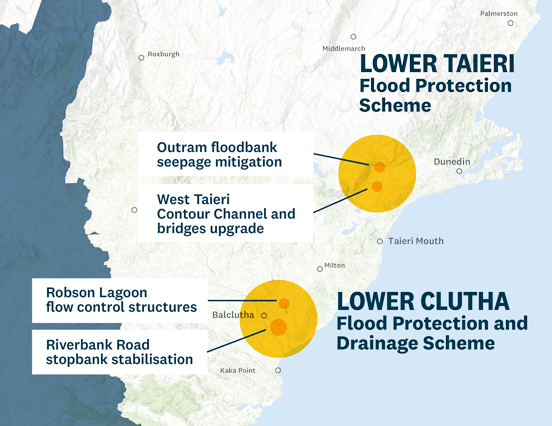
This project is upgrading the Contour Channel, which is a part of the Lower Taieri Flood Protection Scheme in Mosgiel.
The Contour Channel floodbank was constructed in the early 1900s using horse and cart techniques.
The channel collects run-off from the steep streams on the Maungatua Range and conveys it by gravity to the Waipori River. The channel rises and falls, which means some parts are more likely to overtop in floods – these areas of the floodbank could fail quickly.
If the floodbank fails, it could inundate 7,300 hectares of highly productive agricultural land and Dunedin International Airport. The proposed works will bring the flood scheme up to a standard that can be relied upon as a flood defence.
Update August 2024: ORC has welcomed $5.4 million in Government funding to assist with further works on the Taieri Contour Channel flood-bank project.
The Outram floodbank seeps during high river flows (such as the 2017 flood), which may threaten the floodbank’s integrity in the long run. This project will extend the stopbank toe with a weighting blanket, sealing or replacing culverts, constructing bottom stormwater drains, and refilling and sealing weak zones caused by tree roots.
This floodbank is part of the Taieri Flood Protection Scheme, which prevents flooding of up to 4,000 hectares of highly productive agricultural land, Dunedin International Airport and State Highway 87.

This project will stabilise critical flood protection stopbanks along Riverbank Road in the Lower Clutha delta, near Balclutha. The stopbank stabilisation is needed after flood damage caused by the February 2020 floods. Stopbanks will be repaired at four critical sites on Riverbank Road, which runs for 7km along the Mata-Au Branch of the Clutha River from the Riverbank Road bridge near Stirling.
This project will upgrade flow control structures for Robson Lagoon, which is northeast of Balclutha. Infrastructure will be upgraded to help manage floods while protecting the area’s natural and cultural values. The regionally significant Lake Tuakitoto Wetland complex, which includes Robson Lagoon, is in the Clutha-Mata Au catchment, approximately 7km east/northeast of Balclutha. It is part of a catchment serviced by the Lower Clutha Flood Protection and Drainage Scheme. The upgrades will improve flow during floods and provide a more sustainable habitat for local wildlife, such as native fish.

We are holding community information sessions to update local residents on what will be happening in their areas through ORC's Climate Resilience Programme. We are having conversations with the local communities about the work we will be doing to protect their agricultural land and homes from flooding.
Session #1: Lower Clutha
This community drop-in session was held in March 2021 in Balclutha. The purpose of this event was to inform the residents living in Lower Clutha area about shovel-ready flood protection works taking place along Riverbank Road and Robson Lagoon, as part of the Climate Resilience Programme.
Session #2: Lower Taieri
This community drop-in session was held in May 2021 in Mosgiel. We talked about shovel-ready flood protection works along Contour Channel near Dunedin Airport, as well as Taieri River floodbank seepage mitigation near Outram. The words are a part of ORC's Climate Resilience Programme, partially funded by the Ministry of Business, Innovation and Employment.
In July 2020, the central government announced their plans to invest in 'shovel ready’ climate resilience and flood protection projects across New Zealand to help with its economic recovery from COVID-19 and keep communities safer.
In November 2020, the Provincial Development Unit (PDU) in the Ministry of Business, Innovation & Employment (MBIE) and the Otago Regional Council (ORC) finalised an agreement for $5.44 million in government funding for four engineering projects in Otago.
This will fund 60% of the total cost of the projects, while the remaining 40% will be covered by ratepayers’ contributions.
For more information, please read our media release.

Otago’s future climate
Information, tools and reports to help understand climate change impacts and risks across Otago, including effects on communities, the environment, biodiversity and the economy.

Climate-related risks
Climate-related risks are increasing as extreme weather, rising sea levels and warmer temperatures affect our environment, communities and economy. These impacts will not be felt evenly across our region.

What we're achieving in Otago
An overview of Otago Regional Council’s climate resilience work, including adaptation programmes, emissions reduction initiatives, emergency readiness and partnerships with communities and organisations.

What you can do
Ways you can take action on climate change in Otago, including household preparedness, reducing emissions, community initiatives, events and funding opportunities.

Whats happening nationally
Information linking national climate change policies and frameworks with Otago initiatives, including emissions reduction, adaptation planning, resilience research and funding programmes.