-
-
-
-
-
-
-
-
-
-
-
-
-
-
Bungtown Bog
-
-
-
-
-
-
-
-
-
-
-
-
Bungtown Bog
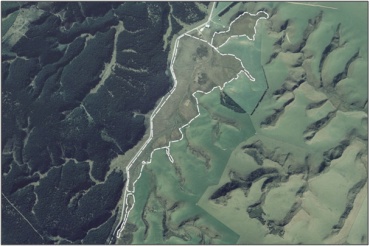
Description: A small area of swamp, including a peat dome. 1
Type/Class: Bog. 2
Size: 17.6 ha.
Altitude: 420-460 m above sea level.
Approximate location: Waipori Road, 7 km Southwest of Mitchells Flat Road, Lawrence. NZTM (centre point): E1351530 N4916200
Regional Plan: Water for Otago | Schedule 9 Regionally Significant Wetland, no.17, Map 47.
Territorial Authority: Clutha District Council.
| Value | Description |
|---|---|
| A4 | High degree of wetland naturalness. 2 |
| A5 | Scarce in Otago in terms of its ecological or physical character. Scarce type of wetland: raised peat dome with Sphagnum sp., wire rush (Empodisma minus), bog pine (Halocarpus bidwillii) and Hebe sp. growing on it. 1 |
| A1 - A6, A7 - A9 | No relevant information is currently held by the ORC. |
- Part of the wetland is administered by the Department of Conservation as a scientific reserve. 1

1 Otago Regional Council (2004) Regional Plan: Water for Otago. Published by the Otago Regional Council, Dunedin.
2 Ausseil, A.G., Newsome, P., Johnson, P. (2008) Wetland Mapping in the Otago Region. Landcare Research Contract Report prepared for the Otago Regional Council.
51 Otago Regional Council – Photo Archive.
Was this page helpful?
Page last updated 5 August 2024
Page last updated 5 August 2024


