-
-
-
-
-
-
-
-
-
-
-
-
-
-
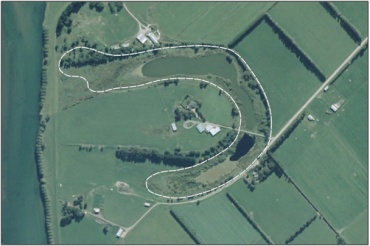
Culcairn Oxbow Marsh
-
-
-
-
-
-
-
-
-
-
-
-
Culcairn Oxbow Marsh
Description: Culcairn Oxbow Marsh.
Type/Class: Marsh. 2
Size: 8.4 ha.
Altitude: 0 - 20 m above sea level.
Approximate location: South West of intersection of Hislop Road and Centre Road, Inch Clutha | NZTM (centre point): E1349800 N4871500
Regional Plan: Water for Otago | Schedule 9 Regionally Significant Wetland, no.33, Map F38.
Territorial Authority: Clutha District Council.
Interactive map of Culcairn Oxbow Marsh
- Presence of Juncus sp. 2
2 Ausseil, A.G., Newsome, P., Johnson, P. (2008) Wetland Mapping in the Otago Region. Landcare Research Contract Report prepared for the Otago Regional Council.
89 Grove, P. (1994) Maniototo Ecological District. Survey Report for the Protected Natural Areas Programme. NZ Protected Natural Area Programme 30. Published by the Department of Conservation, Dunedin.
Was this page helpful?
Page last updated 5 August 2024
Page last updated 5 August 2024


