
Find the latest flow and level information for Otago rivers on our Environmental Data Portal.
View info nowFind the latest flow and level information for Otago rivers on our Environmental Data Portal.
Welcome to the Muddy Creek Flood Study project webpage.
The Muddy Creek Flood Study was completed to help inform future planning and development decisions by Waitaki District Council (WDC), including the current Waitaki District Plan review.
The study uses modern flood assessment tools and detailed landform and elevation data to improve understanding of how flooding may occur across parts of Ōamaru North during a range of flood events, including how floodwater may move across the alluvial fan and surrounding urban area.
Key findings from the study include:
The new flood information provides an improved understanding of flood hazard across the study area. It is not intended or suitable for assessing flood hazard for individual properties and does not replace property-specific flood assessments.
The following documents provide information about the Muddy Creek Flood Study and new flood information.

June 2026
PDF | 3 MB
Providing a plain language summary of the full Muddy Creek Flood Study (Technical Report).

May 2026
PDF | 6 MB
This report provides a planning-level flood hazard analysis for a portion of the Muddy Creek catchment which is located on the north side of the town of Oamaru, in the Waitaki district of Otago. The primary flooding concern in the study area is from over-bank flooding of Muddy Creek. A portion of the study area is located within a mapped alluvial fan.
The new study looked at three different-sized flood events with annual exceedance probabilities of 1%, 2% and 10% — also known as ‘100-year flood’, ‘50-year flood’ and ‘10-year flood’ – and the effects of climate change on flood hazard characteristics.
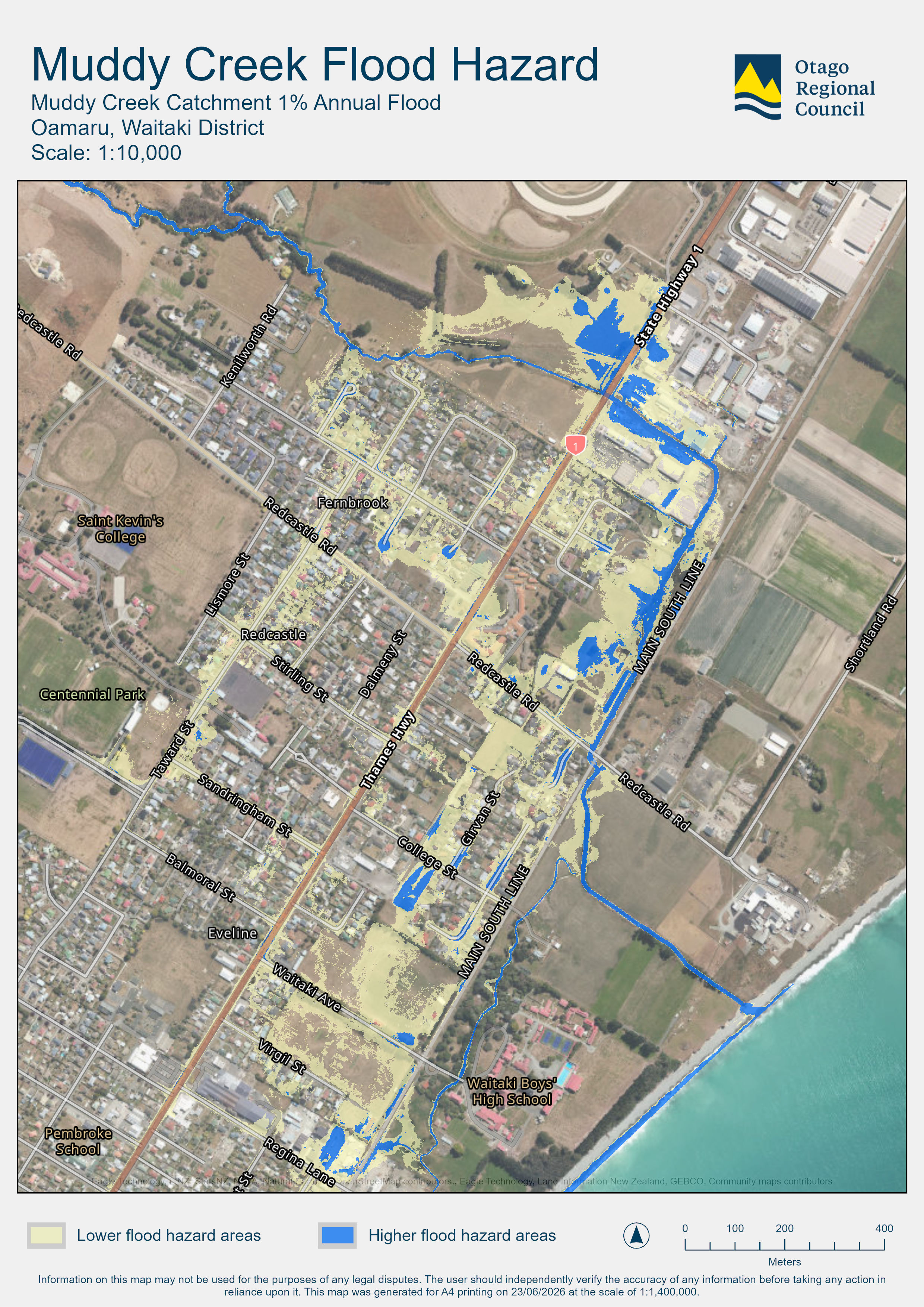
Figure 1 shows the flood hazard extent associated with a large flood event. The map identifies areas of lower flood hazard (yellow) and higher flood hazard (blue) for the 1% annual exceedance probability flood, also known as the ‘100-year flood’.
This is a planning-level study. The new information should be viewed as indicative rather than as an exact boundary. The results are not intended for — and must not be used for — flood hazard assessment at the individual property level.
The Muddy Creek Flood Study uses modern flood assessment tools and makes use of detailed landform and elevation data. It improves understanding of where flooding may occur for a range of flood events and helps to answer questions about flooding in the Muddy Creek catchment.
The Muddy Creek channel has a limited capacity, and during large floods, floodwater is expected to overtop the creek channel into the Ōamaru North urban area and generally flow south, following overland flow paths, including along some streets and roadways.
The flow paths taken by floodwater are heavily influenced by urban development, stormwater systems and past modification of creek channels.
Figure 1 shows the indicative flood hazard extent associated with a large flood event. The map shows areas of lower flood hazard (yellow) and higher flood hazard (blue) for the 1% annual exceedance probability flood, also known as the ‘100-year flood’.
The Muddy Creek Flood Study was completed to help inform future planning and development decisions by Waitaki District Council (WDC), including the current Waitaki District Plan review. It is not intended and must not be used for flood hazard assessment at the individual property level.
Most of the 100-year flood extent (Figure 1) is identified as lower flood hazard (yellow), meaning floodwater is likely to be shallow (less than 30 centimetres), relatively slow moving and not likely to affect people’s safety, vehicle access and building structural stability. Shallow flooding of buildings may still occur in these areas. This depends on the building floor level and local features, such as fences, affecting the overland flow paths.
Floodwater is more likely to affect people’s safety and vehicle access in higher flood hazard (blue) areas; and is also possibly unsafe to buildings within and adjacent to the creek channels. The results also indicate the potential for local areas of deeper or faster-moving floodwater, including along some roadways.
The study is not intended to assess flood hazard for individual properties, and further detailed assessment will be required for future development proposals in some areas.
This is a planning-level study. The new information should be viewed as indicative rather than as an exact boundary. The results are not intended or suitable to assess flood hazard for individual properties. They must not be used for flood hazard assessment at the individual property level.
The new flood hazard information improves the understanding of where flooding may occur for a range of flood events and helps to answer general questions from the community about flooding.
This study has several limitations, which are important to understand:
During an actual event, it is common to get local obstructions and blockages that affect surface flooding in developed areas.
Insurance companies use a wide range of information when assessing risk, and hazard studies are one possible source of information used in those assessments.
The purpose of the study is to inform Waitaki District Planning process and improve general understanding of how flooding may occur. The limitations and uncertainties of the study mean that the results are not suitable for property-specific hazard assessment and must not be used for this.
Otago Regional Council (ORC) does not make decisions about insurance cover or premiums. Questions about individual insurance policies should be discussed directly with insurance providers or brokers.
The new flood information does not automatically affect future development. It does help identify:
Some undeveloped areas may require further flood assessment if development is proposed in the future.
Redevelopment of an existing site may be able to rely on existing use rights; however, the developer/owner may wish to elevate the building to future proof it.
No one is required to move away. This kind of flooding is common on floodwater-dominated alluvial fans and has been identified in other Otago communities.
Most flooding identified in the new flood hazard study is expected to be low hazard, meaning floodwater is generally expected to be shallow and relatively slow-moving, and unlikely to cause structural damage to buildings.
The highest hazard areas are within and adjacent to the creek channels and in local pockets of deeper or faster floodwaters.
If you are concerned about possible flood impacts, you may want to consider ways that your household or business can reduce flood damage (such as flood proofing) and increase awareness and resilience (such as flood action plans).
Community feedback and local knowledge are important parts of understanding how flooding may occur in the Muddy Creek area.
If you have questions or feedback about the new flood hazard information, ORC encourages you to:
The new flood hazard study helps us to understand how Muddy Creek flooding may occur in the Ōamaru North area. The results show that there are likely to be additional surface flow paths through the urban area during large floods when some of the floodwater breaks out of the channels.
ORC, Civil Defence Emergency Management (CDEM), WDC and the community can now work together to understand what this new information means for the Muddy Creek area and use it to help build community resilience.
The new flood information and study findings will now help:
While most flooding identified in the urban area is expected to be shallow and slow moving, floodwater can still create safety risks for people and vehicles during flood events.
During a flood event, you should:
If there is an immediate risk to life or safety, contact emergency services by calling 111.
If your house or business is located within a flood-prone area, it is also recommended that you get ready before flooding occurs.
More information about flood preparedness and safety is available from Otago Civil Defence.
Otago Regional Council (ORC) and Waitaki District Council (WDC) held a community drop-in session on 25 June 2026. ORC staff and Cr Kate Wilson spoke with a steady flow of community members, who asked thoughtful questions, shared their concerns and offered their experiences. Thank you to everyone involved.
If you have questions about the Muddy Creek Flood Study or the new flood information, please contact Otago Regional Council’s Natural Hazards team:

Upstream - Pre spray 2025

Upstream - Pre spray 2025

Upstream - Post spray 2025

Upstream - Post Spray 2025

Upstream - Post Spray 2025


Downstream - Pre Spray 2025

Downstream - Pre Spray 2025

Downstream - Post Spray 2025

Downstream - Post Spray 2025

Downstream - Post Spray 2025

Downstream - Post Spray 2025


Culvert Inlet - Pre Spray 2025

Culvert Inlet - Post Spray 2025

Culvert Outlet - Post Spray 2025

Culvert Inlet - Post Spray 2025


