-
-
-
-
-
-
-
-
-
-
-
-
-
-
-
-
-
Clutha/Mata-au
-
-
-
-
-
-
-
-
-
-
-
-
-
-
-
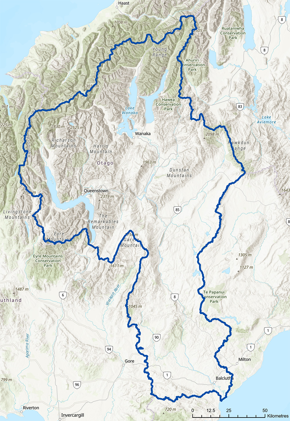
The Clutha/Mata-au is the largest Freshwater Management Unit in Otago, and encompasses the full extent of the river catchment, from the mountains to the sea.
This area has been divided into five sub areas called “rohe” to enable meaningful consultation with different communities in the area, and to ensure a more localised approach to decision-making.

This summary paper provides an overview of the environmental flows and take limits relating to the main stem of the Clutha Mata-au, Kawarau River and Hawea River main stems.
The “Clutha Mata-au main stem” includes the
- Hawea River from Lake Hawea Dam Outlet to the Confluence with Clutha Mata-au
- Kawarau River from outlet of Lake Whakatipu to the Confluence with Clutha Mata-au arm of Lake Dunstan
A map of the Clutha Mata-au main stem is shown below.
The Clutha Mata-Au main stem is a high valued and unique water body. There are many values present and other matters that will inform the setting of take limits and environmental flows, these include:
- High natural character and unique river form
- The Kawarau River and parts of the Clutha Mata-Au main stem have been identified as a potential Outstanding Water Body
- Water Conservation Order on the Kawarau River
- High recreational values
- Ecological habitat/flow relationship is in reverse and not the key driver for setting EFL and take limit (less water means more habitat)
- Renewable electricity generation
- Water quality and the requirement to maintain or improve where degraded
It is proposed to retain existing environmental flow regime as established by the conditions of the resource consents held by Contact Energy Limited for operating hydro-electricity generation infrastructure at the Lake Hawea outlet and the Clyde and Roxburgh dams.
The draft proposed environmental flows for the Clutha Mata-au, Kawarau River and Hawea River main stems are shown in Table 1 below.
Two options have been developed for setting take limits for the Clutha Mata-au main stem, the Kawarau River and the Hawea River.
Both options are shown in table 1.
Option A:
This option proposes a take limit of 5 % of the Clutha Mata-au’s 7dMALF for different sections of the Clutha Mata-au main stem, the Kawarau River and Hawea River. This option reflects a more precautionary approach to limit setting that seeks to provide for the river’s environmental, recreational and cultural values while still providing for future water demand.
Under this option more water it is likely that more water can be allocated from the Clutha Mata-Au main stem, Kawarua and Hawea Rivers.
Both options are shown in table 1
Option B:
This option proposes a take limit at 10 % of the Clutha Mata-au’s 7dMALF for different sections of the Clutha Mata-au main stem, the Kawarau River and Hawea River. This approach is consistent with the approach applied by ORC for developing default take limits for rivers in other parts of the Otago region.
Table 1 Draft proposed environmental flows and take limits for the Clutha Mata-au main stem, the Kawarau River and the Hawea River.
| Name | Environmental flow(s) (l/s) | Take limit (l/s) | Further allocation available (estimate based on best available information) | ||
| Option A | Option B 10 % of 7dMALF |
||||
Upper Clutha
|
Minimum flow of 10,000 l/s for the Hawea River | 5,500 l/s* | 11,000 l/s* | Likely | |
| Kawarau river from outlet of Lake Whakatipu outlet to confluence with Clutha arm of Lake Dunstan at Cromwell | 120,000 l/s below Clyde Dam | 4,650 l/s** | 9,300 l/s ** | Yes | |
| Clyde dam to Roxburgh Dam | 250,000 l/s below Clyde Dam | 4,850 l/s*** | 9,700 l/s*** | Yes | |
| Lower Clutha from below Roxburgh dam to mouth | 250,000 l/s below Roxburgh Dam | ||||
* Based on estimated 7dMALF of upper Clutha Mata-au at confluence with Cardona (111, 000 l/s)
** Based on estimated 7dMALF of MALF of Kawarau River at chards (93,000 l/s)
** Based on estimated 7dMALF of MALF of Clutha Mata-au at mouth (298,000 l/s)

Dunstan Rohe
Within the Clutha Mata-Au FMU, the Dunstan Rohe runs from the outlets of lakes Wānaka, Whakatipu and Hāwea down to the Clyde Dam and includes the Kawarau, Nevis, Shotover, Upper Clutha/Mata-au, Hāwea, Cardrona, Arrow, and Lindis Rivers.

Lower Clutha Rohe
Within the Clutha Mata-Au Freshwater Management Unit (FMU), the Lower Clutha Rohe includes the Pomahaka catchment, as well as several other river catchments that feed the Clutha/Mata-au.

Manuherekia Rohe
Within the Clutha Mata-Au Freshwater Management Unit (FMU), the Manuherekia Rohe is based on the catchment area of the Manuherekia River.

Roxburgh Rohe
Within the Clutha Mata-Au Freshwater Management Unit (FMU), the Roxburgh Rohe extends from the Clyde Dam to Beaumont, and covers Alexandra, Clyde, and Roxburgh.

Upper Lakes Rohe
Within the Clutha Mata-Au Freshwater Management Unit (FMU), the Upper Lakes Rohe covers the lakes of Whakatipu, Wānaka and Hāwea, from their tributaries to their outlets and is around 7,000 square kilometres.
We’re developing a change to the Water Plan to set environmental flows/levels and allocation limits to manage the amount of water in the Clutha River/Mata-au, its lakes and its two main upper catchment tributaries.
We are developing a plan change to Otago’s Regional Plan Water (Water Plan) to manage the amount of water in the Clutha River/Mata-au, its lakes and its two main upper catchment tributaries, the Kawarau and Hawea Rivers. This includes setting minimum flows and allocation limits for the Clutha River/Mata-au, Kawarau and Hawea Rivers and levels and allocation limits for Lakes Wakatipu, Wanaka, Hawea, Dunstan and Roxburgh.
Otago Regional Council (ORC) is required by Government, through the National Policy Statement on Freshwater Management 2017 (NPSFM), to set environmental flows and/or levels for all freshwater management units (FMU) in its region (except ponds and naturally ephemeral water bodies). These must include minimum flows and allocation limits for rivers and streams and minimum water levels and allocation limits for other FMUs. Minimum flows/levels and allocation limits are set in Schedule 2 of the Water Plan.
The changes we make to the Water Plan will be informed by the NPSFM, by environmental, economic, cultural, social, and planning assessments, and with input from the community and people affected by any potential changes.
Before we notify the proposed plan change to the Water Plan, we are holding a series of three community consultation sessions over the coming months to develop the plan change. The feedback we receive from the community will help us to develop the plan change.
In December 2017 we started the first of three stages of public consultation which help shape the development of the plan change for Clutha River/Mata-au, its lakes and its two main upper catchment tributaries, the Kawarau and Hawea Rivers. We asked people to identify what they value about these water bodies and what was important to them. A summary of the feedback received at the consultation sessions and during the feedback period is provided below.
Summary of Feedback - Consultation December 2017 to February 2018
If you want to learn more about what people think is important about the Clutha River/Mata-Au, the large lakes that feed it and its tributaries you can also view our online interactive map below. The interactive map allows you to view recorded feedback on recreation, use, natural and environmental values, community and cultural locations, and issues and concerns.
This interactive mapping tool also contains various 'layers' with information about the catchment, including Land Use Capability, Land Cover, Walking and Biking Tracks, Conservation Areas and Fish Values.
Consultation materials that were used and presented during the first stage of consultation are shown below.
Feedback has now closed.